IMAGES TAKEN NEAR TO
Dukes Way, TEWKESBURY, GL20 5FG
Introduction
This page details the photographs taken nearby to Dukes Way, GL20 5FG by members of the Geograph project.
The Geograph project started in 2005 with the aim of publishing, organising and preserving representative images for every square kilometre of Great Britain, Ireland and the Isle of Man.

There are currently over 7.5m images from over14,400 individuals and you can help contribute to the project by visiting https://www.geograph.org.uk
Image Map
Images are licensed for reuse under creativecommons.org/licenses/by-sa/2.0
Notes
- Clicking on the map will re-center to the selected point.
- The higher the marker number, the further away the image location is from the centre of the postcode.
Image Listing (35 Images Found)
Images are licensed for reuse under creativecommons.org/licenses/by-sa/2.0
Image
Details
Distance
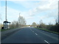
1
Path through Stonehills estate
This path through Stonehills estate roughly follows the route of the former footpath.
Image: © Philip Halling
Taken: 24 Apr 2021
0.07 miles
2
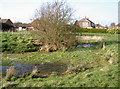
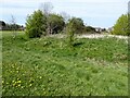
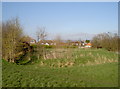
Camp moat
The remnants of the old earthworks have softened over the years but the recent flooding has left a fair amount of water in the bottom of the ditches. It lends some effect of what it perhaps used to look like. Many eminent historians have puzzled over Margaret's Camp, but few believe it was originally part of the Battle of Tewkesbury of 1471. A fairly popular theory relates that this small moated area was part of some older manor house or farmstead. There are some straighter ditches to the west and it's thought they concern water management - something that would be necessary in this low-lying part of Gloucestershire near the River Severn! See Image] for another view.
Image: © Neil Owen
Taken: 10 Mar 2014
0.10 miles
3
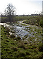
Damp camp
Margaret's Camp, with some recent flooding still in the ditches to mark the old moat. Pity the old mattress dumped in it detracts from a small but interesting historic site.
It is not really known what Margaret's Camp was for or who created it. Certainly, Margaret of Anjou stayed near here before the Battle of Tewkesbury in 1471, but the earthworks are of older date. See Image] for more.
Image: © Neil Owen
Taken: 10 Mar 2014
0.11 miles
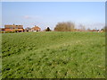
4
Margaret's Camp
Margaret's Camp at Gupshill, this is the site of a former moated manor house and was probably already gone at the time of the Battle of Tewkesbury in 1471.
Image: © Philip Halling
Taken: 24 Apr 2021
0.11 miles
5
Margaret's Camp
View across the ditches towards the moated area of Margaret's Camp. This part of the Gastons (originally called Gastum) saw the two sides of the Yorkist and Lancastrian armies set camp before the battle of 1471, although the earthworks here pre-date it. See Image] for another view.
Image: © Neil Owen
Taken: 10 Mar 2014
0.12 miles
6
Margaret's Camp
Margaret's Camp at Gupshill, this is the site of a former moated manor house and was probably already gone at the time of the Battle of Tewkesbury in 1471.
Image: © Philip Halling
Taken: 24 Apr 2021
0.12 miles
7
Margaret's Camp
Margaret's Camp at Gupshill, this is the site of a former moated manor house and was probably already gone at the time of the Battle of Tewkesbury in 1471.
Image: © Philip Halling
Taken: 24 Apr 2021
0.12 miles
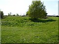
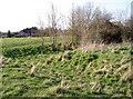
8
Moated mound
This is Margaret's Camp, an area of the Gastons that has puzzled historians for a long time. Although it seems certain that Margaret of Anjou, queen to Henry VI, did actually establish a camp here before the battle of 1471 (and hence the name), the earthworks are rather older. Intriguingly, the highest point is a squarish mound of about 30m width, with some watery ditches around it and an 'L-shaped' embankment to the west of it. Other ditches lead off toward Gupshill Manor. See Image] for more views.
Image: © Neil Owen
Taken: 10 Mar 2014
0.12 miles
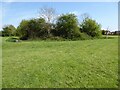
9
Camp ditches
Margaret's Camp, south of the older part of Tewkesbury, has a small earthworks that are popularly known as such. This is looking westwards to take in some of the inner platform, remnants of the moat and some of the outer raised ground. See Image] for more.
Image: © Neil Owen
Taken: 10 Mar 2014
0.12 miles