IMAGES TAKEN NEAR TO
Barn Lane, RUARDEAN, GL17 9YF
Introduction
This page details the photographs taken nearby to Barn Lane, GL17 9YF by members of the Geograph project.
The Geograph project started in 2005 with the aim of publishing, organising and preserving representative images for every square kilometre of Great Britain, Ireland and the Isle of Man.

There are currently over 7.5m images from over14,400 individuals and you can help contribute to the project by visiting https://www.geograph.org.uk
Image Map (Loading...)


Getting Data...Please wait
Leaflet Map data © OpenStreetMap
Images are licensed for reuse under creativecommons.org/licenses/by-sa/2.0
Notes
- Clicking on the map will re-center to the selected point.
- The higher the marker number, the further away the image location is from the centre of the postcode.
Image Listing (26 Images Found)
Images are licensed for reuse under creativecommons.org/licenses/by-sa/2.0
Image
Details
Distance
1
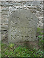
Boundary Stone, Ruardean
One of the many replacement boundary stone delineating the periphery of the "Forest of Dean". The "Forest" is very specific because resident have "rights in common" like grazing sheep and coal mining, though you may have to be born there to classify as a "free miner". This is on the Northern verge in Barn Lane.
Inscription: D. F. / 2012 / Nᴼ. 121
Milestone Society National ID: GL_DFDRYB121em
Image: © Mr Red
Taken: 27 Sep 2022
0.03 miles
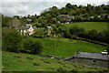
2
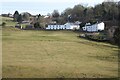
Houses at Ruardean Woodside
This is a post-industrial landscape, this was a former site of a coalmine. Today the land has been reclaimed.
Image: © Philip Halling
Taken: 5 Feb 2023
0.03 miles
3
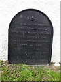
Commemorative Plate, Ruardean
On the wall of a corner house in Meend Lane (with Barn Lane).
Inscription:
V(crown)R
This road for the distance
of 2675 ↢ yards was made
at the expense of the crown
for the benefit of the
inhabitants and district
1899 - 1900
E.Stafford Howard Esq
Commissioner
Philip Baylis Esq
Dep Surveyor
Milestone Society National ID: GL_DRYBR01cm
Image: © Mr Red
Taken: 27 Sep 2022
0.05 miles
4
Farmland near Ruardean Woodside
Looking over the houses on the Northern edge of Ruardean Woodside.
Image: © Stuart Wilding
Taken: 11 Jan 2014
0.06 miles
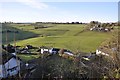
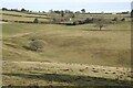
5
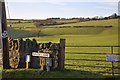
View by Barn Lane
Looking across the fields from Barn Lane in Ruardean Woodside.
Image: © Stuart Wilding
Taken: 11 Jan 2014
0.07 miles
6
Ruardean Woodside
This village high in the Forest of Dean used to be a coal mining village, though most of the scars have healed there is still some evidence, for example a spoil heap can be seen to the left just below the skyline.
Image: © Philip Halling
Taken: 10 May 2009
0.07 miles
7
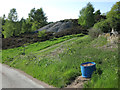
Spoil heap, Ruardean Woodside
From an old coal mine.
Image: © Hugh Venables
Taken: 26 May 2013
0.09 miles
9
Post industrial landscape
In the past this land at Ruardean Woodside was a coalmine. This post industrial landscape has now been reclaimed.
Image: © Philip Halling
Taken: 5 Feb 2023
0.11 miles
10
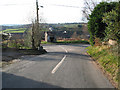
Junction of two country roads, Ruardean Woodside
Turn left to Brierley - turn right to Ruardean.
Image: © Pauline E
Taken: 12 Dec 2007
0.12 miles