IMAGES TAKEN NEAR TO
Varnister Road, RUARDEAN, GL17 9XD
Introduction
This page details the photographs taken nearby to Varnister Road, GL17 9XD by members of the Geograph project.
The Geograph project started in 2005 with the aim of publishing, organising and preserving representative images for every square kilometre of Great Britain, Ireland and the Isle of Man.

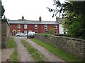
There are currently over 7.5m images from over14,400 individuals and you can help contribute to the project by visiting https://www.geograph.org.uk
Image Map (Loading...)


Getting Data...Please wait
Leaflet Map data © OpenStreetMap
Images are licensed for reuse under creativecommons.org/licenses/by-sa/2.0
Notes
- Clicking on the map will re-center to the selected point.
- The higher the marker number, the further away the image location is from the centre of the postcode.
Image Listing (29 Images Found)
Images are licensed for reuse under creativecommons.org/licenses/by-sa/2.0
Image
Details
Distance
1
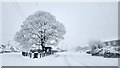
Ruardean Oak and war memorial
Early on a morning of December snow.
The grey marks on the sky are snowflakes.
Image: © Jonathan Billinger
Taken: 11 Dec 2022
0.07 miles
2
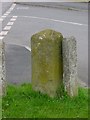
Old Milestone by High Street/Varnister Road junction, Ruardean
Carved stone post by the UC road, in parish of RUARDEAN (FOREST OF DEAN District), at junction, on grass verge, on North side of road. Ross Forest stone, erected by the Forest of Dean turnpike trust in the 19th century.
Inscription reads:-
2 MILE / TO / NAIL / BRIDGE // TO / ROSS // 2[?] MILE / TO / CINDERFORD
Milestone Society National ID: GL_RSNB05
Image: © K Walker & R Harvey
Taken: 30 Apr 2005
0.08 miles
3
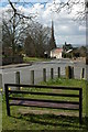
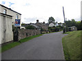
Seat in Ruardean
View down the main road through the village of Ruardean. The spire of St John the Baptist's church can be seen in the middle distance.
Image: © Philip Halling
Taken: 30 Mar 2008
0.11 miles
4
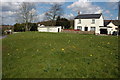
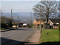
Rural community of Crooked End
View along the minor road from Hope Mansell.
Image: © Pauline E
Taken: 15 Sep 2010
0.13 miles
5
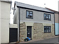
Cottage in Ruardean
Cottage at Crooked End in Ruardean.
Image: © Philip Halling
Taken: 30 Mar 2008
0.13 miles
6
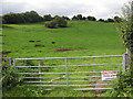
Taken on the county boundary
To the left, Gloucestershire, to the right, Herefordshire. The cows and calves are behind the hedgerow on the right.
Image: © Pauline E
Taken: 15 Sep 2010
0.17 miles
7
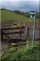
Footpaths to Ruardean
Footpaths sign at Barrelhill near Ruardean.
Image: © Philip Halling
Taken: 30 Mar 2008
0.17 miles
8
Toll House, Ruardean
Former Toll House, "Pike Cottage" on the North side of High Street. Used by the Forest of Dean Turnpike Trust up until the 19ᵗʰ C. Parts of Ruardean are in the "Forest" but the High Street is not.
Milestone Society National ID: GL.RUA
Image: © Mr Red
Taken: 27 Sep 2022
0.18 miles
9
The Black Mountains from Ruardean
Ruardean is one of the highest points in the Forest of Dean. Here you can clearly see the Black Mountains in the distance. Waun Fach is the highest point between the two telegraph poles.
Image: © Stuart Wilding
Taken: 9 Feb 2006
0.19 miles