IMAGES TAKEN NEAR TO
Bevan Rise, CINDERFORD, GL14 2UJ
Introduction
This page details the photographs taken nearby to Bevan Rise, GL14 2UJ by members of the Geograph project.
The Geograph project started in 2005 with the aim of publishing, organising and preserving representative images for every square kilometre of Great Britain, Ireland and the Isle of Man.

There are currently over 7.5m images from over14,400 individuals and you can help contribute to the project by visiting https://www.geograph.org.uk
Image Map (Loading...)


Getting Data...Please wait
Leaflet Map data © OpenStreetMap
Images are licensed for reuse under creativecommons.org/licenses/by-sa/2.0
Notes
- Clicking on the map will re-center to the selected point.
- The higher the marker number, the further away the image location is from the centre of the postcode.
Image Listing (34 Images Found)
Images are licensed for reuse under creativecommons.org/licenses/by-sa/2.0
Image
Details
Distance
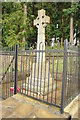
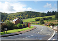
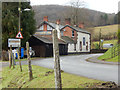
2
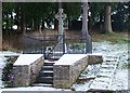
War Memorial, Soudley
The War Memorial is at the T- junction with the main road through the village of Soudley and the spur leading to Littledean. It is fenced and gated, I suspect because of the free-roaming sheep in the Forest.
Image: © Eric Soons
Taken: 5 Jan 2009
0.04 miles
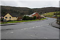
4
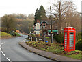
Top Road, Upper Soudley
Looking towards the White Horse Inn with a still functioning telephone box. There are plans to close the box, a controversial move because mobile reception is poor in this area.
Image: © Stephen McKay
Taken: 11 Dec 2016
0.07 miles
5
Top Road, Upper Soudley
A bit higher up the hillside than Lower Road.
Image: © Des Blenkinsopp
Taken: 24 Sep 2019
0.07 miles
6
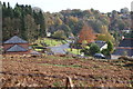
Looking down on Soudley
The bracken field is sometimes used for training motorcyclists along a circular grass track. The T-junction by the telephone box leads off to Littledean on the left and on towards Blakeney and the A48.
Image: © Eric Soons
Taken: 7 Nov 2008
0.07 miles
7
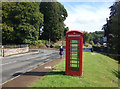
Phone Box, Top Road, Upper Soudley
In a prominent location on a neat bit of verge. Still quite red and with all its windows, and a phone inside. A rare specimen these days.
Image: © Des Blenkinsopp
Taken: 24 Sep 2019
0.07 miles
9
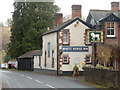
The White Horse Inn, Upper Soudley
Village pub on Church Road apparently noted for snail racing.
Image: © Stephen McKay
Taken: 11 Dec 2016
0.08 miles
10
Church Road, Upper Soudley
Ahead is the White Horse Inn. The road through the heart of the Forest of Dean is designated a scenic route. The entrance on the immediate left gives access to the pub car park but at one time there was a station here on the long-closed Cinderford branch.
Image: © Stephen McKay
Taken: 11 Dec 2016
0.08 miles