IMAGES TAKEN NEAR TO
Brownings Close, STONEHOUSE, GL10 3GD
Introduction
This page details the photographs taken nearby to Brownings Close, GL10 3GD by members of the Geograph project.
The Geograph project started in 2005 with the aim of publishing, organising and preserving representative images for every square kilometre of Great Britain, Ireland and the Isle of Man.

There are currently over 7.5m images from over14,400 individuals and you can help contribute to the project by visiting https://www.geograph.org.uk
Image Map
Images are licensed for reuse under creativecommons.org/licenses/by-sa/2.0
Notes
- Clicking on the map will re-center to the selected point.
- The higher the marker number, the further away the image location is from the centre of the postcode.
Image Listing (44 Images Found)
Images are licensed for reuse under creativecommons.org/licenses/by-sa/2.0
Image
Details
Distance
1
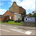
Brownings Close, Eastington
Viewed across Bath Road. The large notice on the left refers to private parking for the adjacent Kings Head House.
Image: © Jaggery
Taken: 29 Jun 2014
0.00 miles
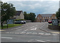
2
Brownings Close, Eastington, Gloucestershire
Viewed from Bath Road near the Alkerton Road junction.
Image: © Jaggery
Taken: 7 Aug 2016
0.01 miles
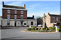
3
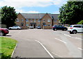
The King's Head House, Eastington
Bath Road hotel, restaurant and conference centre.
Image: © Jaggery
Taken: 29 Jun 2014
0.03 miles
4
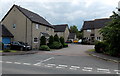
Lea Court, Eastington
Short cul-de-sac viewed across Bath Road.
Image: © Jaggery
Taken: 29 Jun 2014
0.03 miles
5
King's Head House name sign, Eastington
Facing Bath Road at the SE corner of King's Head House. https://www.geograph.org.uk/photo/4049201
Image: © Jaggery
Taken: 7 Aug 2016
0.03 miles
6
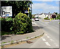
Bath Road directions sign, Eastington
Alongside Bath Road on the approach to the roundabout at the Alkerton Road junction.
Image: © Jaggery
Taken: 7 Aug 2016
0.03 miles
7
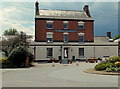
The Kings Head, Eastington
The Kings Head and finger post in the village of Eastington.
Image: © Philip Halling
Taken: 29 Oct 2011
0.04 miles
8
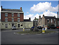
Roundabout at Alkerton, Eastington
At the junction of Alkerton Road and Bath Road. I don't know anything about the stone cross, but it clearly pre-dates the roundabout. The 'King's Head' on the south side of the junction is a late-18th or early-19th-century brick house with a cornice and a parapet, a doorway with a fan-light, and a porch with Doric columns; it was a public house by 1834.
Image: © Phil Champion
Taken: 20 Aug 2005
0.04 miles
9
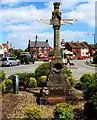
Victorian direction post on an Eastington roundabout
Erected here https://www.geograph.org.uk/photo/5835784 in 1897 to commemorate Queen Victoria's Diamond Jubilee.
The structure included a drinking fountain, now eroded. Grade II listed in 1986.
Image: © Jaggery
Taken: 7 Aug 2016
0.04 miles
10
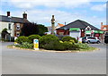
Roundabout in the centre of Eastington
At the junction of Bath Road and Alkerton Road. https://www.geograph.org.uk/photo/5835804 to a closer view of the Victorian direction post.
Image: © Jaggery
Taken: 7 Aug 2016
0.04 miles