IMAGES TAKEN NEAR TO
Kent Drive, HELENSBURGH, G84 9RS
Introduction
This page details the photographs taken nearby to Kent Drive, G84 9RS by members of the Geograph project.
The Geograph project started in 2005 with the aim of publishing, organising and preserving representative images for every square kilometre of Great Britain, Ireland and the Isle of Man.

There are currently over 7.5m images from over14,400 individuals and you can help contribute to the project by visiting https://www.geograph.org.uk
Image Map
Images are licensed for reuse under creativecommons.org/licenses/by-sa/2.0
Notes
- Clicking on the map will re-center to the selected point.
- The higher the marker number, the further away the image location is from the centre of the postcode.
Image Listing (24 Images Found)
Images are licensed for reuse under creativecommons.org/licenses/by-sa/2.0
Image
Details
Distance
1
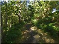
Footpath in Garrawy Glen
The path is on the east side of the burn (Image), and here runs parallel to it.
Image: © Lairich Rig
Taken: 8 Oct 2015
0.09 miles
2
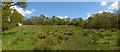
Grassy space near Helensburgh
This area is between the houses of Churchill Estate (background left) and the wooded Garrawy Glen, which is behind a metal fence on the right.
Image: © Lairich Rig
Taken: 22 May 2013
0.09 miles
3
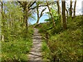
Path in Garrawy Glen
This part of the path is near the edge of the woods; the boundary between the woods and the adjacent field is at the top of the slope on the right.
Image: © Lairich Rig
Taken: 22 May 2013
0.10 miles
4
The steep eastern side of Garrawy Glen
The glen itself is said to have been a meltwater channel for the glaciers of the Loch Lomond Readvance. In that connection, the first paper cited below mentions the NW—SE trend of drumlins at nearby Townhead Farm.
Ref: "The significance of blocks of shelly till from Townhead Farm, Helensburgh (P MacDonald, pages 41—42 of West Dunbartonshire Naturalist Report No 6; West Dunbartonshire Natural History Society, 1984).
This in turn cites:
Browne M A E, McMillan A A, Hall I H S (1983), "Blocks of marine clay in till near Helensburgh, Strathclyde", Scott. J. Geol., 19, 321—25.
Image: © Lairich Rig
Taken: 24 Apr 2017
0.10 miles
5
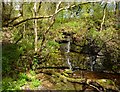
Waterfall in Garrawy Glen
This is the waterfall that is marked on the 1:25000 map. On this occasion, the flow was no more than a trickle; the weather had been drier than usual.
Image: © Lairich Rig
Taken: 22 May 2013
0.10 miles
6
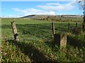
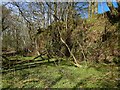
Field boundary beside Garrawy Glen
The view is from the top of Image The stone looked as though it could be a boundary marker, but I did not notice any distinctive marks on it.
Image: © Lairich Rig
Taken: 24 Apr 2017
0.10 miles
7
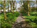
Woodland path in Churchill Estate
The properties in the background are on a street called Hardy Hill; they were being refurbished when this picture was taken.
See also Image
Image: © Lairich Rig
Taken: 22 May 2013
0.10 miles
8
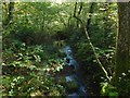
Burn in Garrawy Glen
This view downstream is from a Image
Image: © Lairich Rig
Taken: 8 Oct 2015
0.11 miles
9
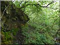
Rock face in Garrawy Glen
The burn is on the right (east), but the picture is intended to show the rock face on the western side of the glen. The waterfall that is marked on the 1:25000 map is just upstream, but was not well seen from here on account of the dense tree cover.
For a view in the opposite direction, see Image
Image: © Lairich Rig
Taken: 17 Aug 2016
0.11 miles
10
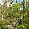
Footbridge in Garrawy Glen
The footbridge leads over the burn that flows through the glen; further upstream, the glen is steeper: Image
The waterfall that is marked on the 1:25000 OS map is only a short distance downstream from this bridge: Image
Image: © Lairich Rig
Taken: 22 May 2013
0.11 miles