IMAGES TAKEN NEAR TO
Artarman Road, HELENSBURGH, G84 8LQ
Introduction
This page details the photographs taken nearby to Artarman Road, G84 8LQ by members of the Geograph project.
The Geograph project started in 2005 with the aim of publishing, organising and preserving representative images for every square kilometre of Great Britain, Ireland and the Isle of Man.

There are currently over 7.5m images from over14,400 individuals and you can help contribute to the project by visiting https://www.geograph.org.uk
Image Map
Images are licensed for reuse under creativecommons.org/licenses/by-sa/2.0
Notes
- Clicking on the map will re-center to the selected point.
- The higher the marker number, the further away the image location is from the centre of the postcode.
Image Listing (44 Images Found)
Images are licensed for reuse under creativecommons.org/licenses/by-sa/2.0
Image
Details
Distance
1
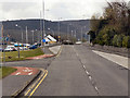
The foot of Artarman Road, Rhu
The view is from the junction with the shore road.
Image: © Lairich Rig
Taken: 1 Nov 2016
0.08 miles
2
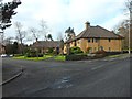
Woodstone Court
Residential area in Rhu, Argyll and Bute.
Image: © Stephen Sweeney
Taken: 19 Feb 2012
0.10 miles
3
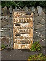
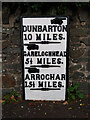
Old milestone at Rhu
The stone is set in a wall next to a bus stop on Image (see that photograph for context). The milestone is an old one; it is shown, at or near its present position, on the first-edition OS map (surveyed in 1860).
"Dunbarton 10 miles / Garelochhead 5½ miles / Arrochar 15½ miles"
The spelling "Dunbarton" is one that was favoured by the Trustees of Turnpike Roads (for reasons that are explained in Image). Compare Image
Image: © Lairich Rig
Taken: 12 Sep 2012
0.11 miles
4
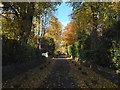
Lover's Lane
A Right of Way leading to Torwoodhill Road.
Image: © Richard Sutcliffe
Taken: 5 Sep 2023
0.11 miles
5
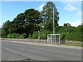
Old milepost
This milepost in Rhu is one of the flat designs which are only 7cm deep. The mileposts between Dumbarton and Helensburgh are curved with a different style of hands. It is marked on the 1860 OS map but only this post on the A814 opposite the marina and a similar post in Arrochar remain by the roadside along the eastern shore of Gare Loch and Loch Long.
Image: © Hilary Jones
Taken: 10 Aug 2023
0.11 miles
6
Old milepost
Looking west along the A814 which shortly turns north alongside Gare Loch. The marina is behind the houses on the left.
Image: © Hilary Jones
Taken: 10 Aug 2023
0.11 miles
7
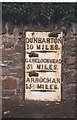
Old Milepost by the A814, Gareloch Road, Rhu, Row parish
Glasgow flat by the A814, in parish of Row (Argyll & Bute District), Rhu, Gareloch Road, on front of wall, West of bus shelter, North side of road.
Inscription reads:-
{hand->}
DUNBARTON
10 MILES
{line}
{<-hand}
GARELOCHHEAD
5½ MILES
{line}
{<-hand}
ARROCHAR
15½ MILES
{line}
Surveyed
Milestone Society National ID: AB_DMAC10
Image: © Milestone Society
Taken: Unknown
0.11 miles
8
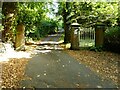
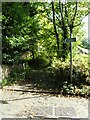
Drive to Invergare and Rowaleyn
The gate and gate piers mark the end of the public road (Glenarn Road). Beyond is a private lane for residents only.
Image: © Richard Sutcliffe
Taken: 5 Sep 2023
0.11 miles
10
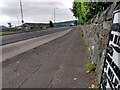
Gareloch Road
The bus stop faces a road leading to Rhu Marina, and is just out of shot to the right in another photo: Image In the present photograph, the object that is set in the wall, just left of centre, is an old milestone; for a closer look, see Image
Image: © Lairich Rig
Taken: 12 Sep 2012
0.11 miles