IMAGES TAKEN NEAR TO
HELENSBURGH, G84 7JZ
Introduction
This page details the photographs taken nearby to G84 7JZ by members of the Geograph project.
The Geograph project started in 2005 with the aim of publishing, organising and preserving representative images for every square kilometre of Great Britain, Ireland and the Isle of Man.

There are currently over 7.5m images from over14,400 individuals and you can help contribute to the project by visiting https://www.geograph.org.uk
Image Map (Loading...)


Getting Data...Please wait
Leaflet Map data © OpenStreetMap
Images are licensed for reuse under creativecommons.org/licenses/by-sa/2.0
Notes
- Clicking on the map will re-center to the selected point.
- The higher the marker number, the further away the image location is from the centre of the postcode.
Image Listing (22 Images Found)
Images are licensed for reuse under creativecommons.org/licenses/by-sa/2.0
Image
Details
Distance
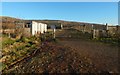
1
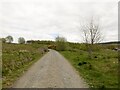
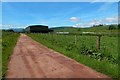
Farm road, Camis Eskan
A recently built road serving a byre and forestry.
Image: © Richard Webb
Taken: 26 Apr 2022
0.08 miles
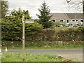
4
Road to Craigendoran
A house called Woodhead Cottage is directly ahead. In the left foreground is the start of the driveway to another house, Tigh-na-Mara.
Image: © Lairich Rig
Taken: 23 Nov 2016
0.12 miles
5
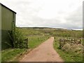
Track to Craigendoran
The track is part of the Three Lochs Way. The buildings on the left also appear in Image; for the house in the right background, see Image
See Image for a view in the opposite direction from roughly the same point.
Image: © Lairich Rig
Taken: 6 Jun 2014
0.12 miles
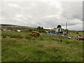
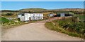
6
Camis Eskan Farm
The buildings of Camis Eskan Farm have been converted for residential use, but they retain their former name. On early OS maps, the buildings are simply labelled Home Farm.
See Image for the nearby mansion, which was (in the late nineteenth century) the property and family residence of Colin Campbell (see Image and Image).
Image: © Lairich Rig
Taken: 3 May 2012
0.13 miles
8
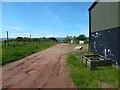
Passing farm buildings
Compare Image, a view in the opposite direction from the other side of the gate that can be seen further ahead on the track.
Image: © Lairich Rig
Taken: 6 Jun 2014
0.13 miles
9
The Three Lochs Way near Camis Eskan
The path is marked on the 1:25000 map. See Image for a view back towards this point from farther ahead.
Image: © Lairich Rig
Taken: 23 Nov 2016
0.13 miles
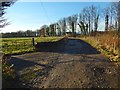
10
The Three Lochs Way
There is a marker for the route on the right-hand wooden gatepost (see Image for another example). The big green barn on the right and the building next to it are the ones that are referred to in the description for Image; they are distantly visible in that view.
The present photograph is a view back along the route; I was travelling in the opposite direction. The track shown in the foreground continues in a south-westerly direction until it joins the main road through Craigendoran.
See Image for a view in the opposite direction.
Image: © Lairich Rig
Taken: 3 May 2012
0.13 miles