IMAGES TAKEN NEAR TO
Ashley Rise, ALEXANDRIA, G83 9NL
Introduction
This page details the photographs taken nearby to Ashley Rise, G83 9NL by members of the Geograph project.
The Geograph project started in 2005 with the aim of publishing, organising and preserving representative images for every square kilometre of Great Britain, Ireland and the Isle of Man.

There are currently over 7.5m images from over14,400 individuals and you can help contribute to the project by visiting https://www.geograph.org.uk
Image Map
Images are licensed for reuse under creativecommons.org/licenses/by-sa/2.0
Notes
- Clicking on the map will re-center to the selected point.
- The higher the marker number, the further away the image location is from the centre of the postcode.
Image Listing (106 Images Found)
Images are licensed for reuse under creativecommons.org/licenses/by-sa/2.0
Image
Details
Distance
1
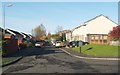
Ashley Rise, Strathleven Estate
This photograph was taken from the southern end of the street, where it meets Strathleven Drive.
Image: © Lairich Rig
Taken: 14 Nov 2010
0.01 miles
2
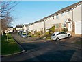
Lady's Gate, Strathleven Estate
This is a view from the southern end of the street. Directly behind the photographer's position is a meadow crossed by a footpath; in fact, the photograph was taken from the edge of the meadow, which is shown in Image and Image
Not far away is Image
Image: © Lairich Rig
Taken: 14 Nov 2010
0.08 miles
3
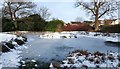
Frozen pond near Strathleven House
The pond is located in a wooded area about 200 metres ENE of Image
The houses in the background are in Strathleven Estate.
For other views, see Image and Image
Image: © Lairich Rig
Taken: 1 Jan 2010
0.10 miles
4
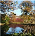
Pond near Strathleven House
Compare Image and Image, which show the same pool. As in those photographs, the houses in the background are in Strathleven Estate.
Image: © Lairich Rig
Taken: 14 Nov 2010
0.10 miles
5
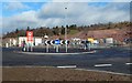
Mill Fields: a new roundabout
Stirling Road is in the foreground, and the Mill Fields construction site is in the background. An existing junction here has been given a new roundabout.
The red sign says "no right turn for construction traffic".
Image: © Lairich Rig
Taken: 20 Feb 2017
0.11 miles
6
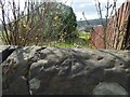
Rivet bench mark on wall
The stone wall is alongside the pavement on the western side of Stirling Road. The same wall appears on the left in a picture of Image; from the point where that picture was taken, the bench mark is about 100 metres further along the wall.
In the present picture, the wooden fence separates an area of housing (Strathleven Estate) from the meadow on the left, just as indicated on the map (the view direction for the picture was chosen to make this correspondence with the map easier to see).
A rivet can be seen on the top of the wall, with an arrow-like cut mark pointing at it. According to the Ordnance Survey's own records, this third-order rivet bench mark is 36.023 metres above Newlyn Datum.
The following description, written by another contributor, explains the terminology.
Image: © Lairich Rig
Taken: 12 Apr 2014
0.11 miles
7
Pond near Strathleven House
The houses in the background, centre to right, are in Strathleven Estate. The structure in the left background is an old doocot that stands near Image; it is shown separately in Image
For earlier pictures, see Image and Image
Image: © Lairich Rig
Taken: 12 Apr 2014
0.11 miles
8
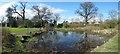
Pond beside Strathleven House
See Image for a view from another angle. The pond is an old feature of the estate: it is represented on the first-edition OS map of 1860.
The present picture was taken a few seconds after an autogiro (which I managed to photograph) had flown almost overhead; see the comments at Image
Image: © Lairich Rig
Taken: 22 May 2016
0.11 miles
9
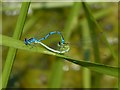
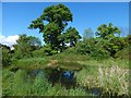
Mating damselflies
These are Azure Damzelflies, Coenagrion puella, at the margin of a Image There were many damselflies here, and some larger species: see Image
Image: © Lairich Rig
Taken: 5 Jun 2016
0.11 miles
10
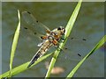
Four-spotter Chaser
(Libellula quadrimaculata)
This dragonfly and many damselflies (see Image) were at the margins of a Image
Image: © Lairich Rig
Taken: 5 Jun 2016
0.11 miles