IMAGES TAKEN NEAR TO
Braehead, ALEXANDRIA, G83 9NG
Introduction
This page details the photographs taken nearby to Braehead, G83 9NG by members of the Geograph project.
The Geograph project started in 2005 with the aim of publishing, organising and preserving representative images for every square kilometre of Great Britain, Ireland and the Isle of Man.

There are currently over 7.5m images from over14,400 individuals and you can help contribute to the project by visiting https://www.geograph.org.uk
Image Map
Images are licensed for reuse under creativecommons.org/licenses/by-sa/2.0
Notes
- Clicking on the map will re-center to the selected point.
- The higher the marker number, the further away the image location is from the centre of the postcode.
Image Listing (27 Images Found)
Images are licensed for reuse under creativecommons.org/licenses/by-sa/2.0
Image
Details
Distance
1
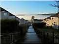
Steps at Braehead
The mist had receded earlier, but, resurgent under a cloudless sky, it now reached almost to the top of the housing estates. The view is from the top of Braehead; Carman Hill and adjacent muirs can be seen in the right background.
Image: © Lairich Rig
Taken: 23 Dec 2018
0.03 miles
2
Bonhill Community Garden
This was a recent initiative; the garden was created in 2018.
Image: © Lairich Rig
Taken: 23 Dec 2018
0.08 miles
3
Path leading down towards Braehead
Two different paths lead downhill from the point that is shown in Image; the last part of the more northerly of the two paths is shown here.
Both paths lead to this area, at the top of Braehead, where one of the access points of the community woodland is located (as indicated by some markers: Image).
See Image for the same view in winter, and for background details.
Image: © Lairich Rig
Taken: 8 Oct 2012
0.08 miles
4
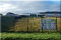
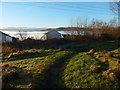
Pappert Well Community Woodland
The gate shown in this photograph is located at one of the three main entry points to Pappert Well Community Woodlands; see also Image
The nearer houses beyond the gate are in the Braehead area, while the more distant background houses are in other parts of the Vale of Leven. On the skyline, in the right-hand side of the image, are Carman Hill (Image) and the muirs that lie to its north.
Image: © Lairich Rig
Taken: 6 Feb 2009
0.08 miles
5
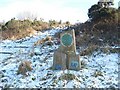
Pappert Well Community Woodlands - markers
There are three main entry points to this area of community woodland, with a marker, or markers, at each one.
The back of the tallest of these three markers can just be made out, silhouetted against the snow, in the following image: Image (in that image, the markers are located in front of the wooden posts that are to the left of the gate).
For the markers at the other two locations, see Image and Image
Image: © Lairich Rig
Taken: 6 Feb 2009
0.08 miles
6
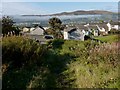
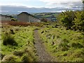
Approaching Braehead
This picture was taken from the point where the path shown in Image turns to the right.
This last section of the path leaves the community woodland not far ahead, beside some markers (Image) that indicate one of the access points.
Another downhill path leads to the same point; see Image, which shows the end-point of both paths at the top of Braehead.
The body of water visible in the background of the present photograph is Loch Lomond.
Image: © Lairich Rig
Taken: 8 Oct 2012
0.09 miles
7
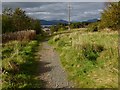
Path from Pappert Hill
The path leads to the top of the housing in Braehead, visible ahead.
Image: © Lairich Rig
Taken: 23 Dec 2018
0.09 miles
8
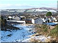
Path leading down towards Braehead
The picture was taken from the same spot as Image, but is a view downhill. The houses visible just ahead are in Braehead. As this picture shows, the path turns right before leaving the community woodland; see Image for the view ahead from that corner.
Image: © Lairich Rig
Taken: 8 Oct 2012
0.11 miles
9
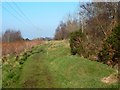
Path above New Bonhill
As the map shows, this path through the community woodland is only just above the upper edge of the housing estates.
Throughout the area, plantations are laid out on areas of parallel ridges and furrows; these planted areas are often bounded by an embankment: here, one such embankment can be seen just to the right of the path.
Image: © Lairich Rig
Taken: 14 Feb 2017
0.12 miles
10
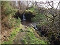
Burn flowing over a path
The pool is pebbly and shallow, and it is easy to cross there. The 1:25000 map shows the course of the burn, and has the label "waterfalls" at this point, referring to the fall just above the path, and the one just below. Both appear in this picture, although the tree on the right makes it difficult to obtain a clear view of the waterfall there.
Image: © Lairich Rig
Taken: 10 Feb 2017
0.14 miles