IMAGES TAKEN NEAR TO
Braehead, ALEXANDRIA, G83 9ND
Introduction
This page details the photographs taken nearby to Braehead, G83 9ND by members of the Geograph project.
The Geograph project started in 2005 with the aim of publishing, organising and preserving representative images for every square kilometre of Great Britain, Ireland and the Isle of Man.

There are currently over 7.5m images from over14,400 individuals and you can help contribute to the project by visiting https://www.geograph.org.uk
Image Map
Images are licensed for reuse under creativecommons.org/licenses/by-sa/2.0
Notes
- Clicking on the map will re-center to the selected point.
- The higher the marker number, the further away the image location is from the centre of the postcode.
Image Listing (43 Images Found)
Images are licensed for reuse under creativecommons.org/licenses/by-sa/2.0
Image
Details
Distance
1
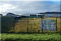
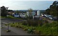
Bonhill Community Garden
This was a recent initiative; the garden was created in 2018.
Image: © Lairich Rig
Taken: 23 Dec 2018
0.07 miles
2
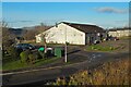
Shops at the top of Beechwood
A takeaway and other shops in the Beechwood and Wheatcroft Estate, seen across Image The unseen left-hand (west) side of the building is shown in Image
Image: © Lairich Rig
Taken: 24 Dec 2020
0.08 miles
3
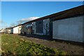
Shops at the top of Beechwood
In the Beechwood and Wheatcroft Estate. For context, see Image, which shows the whole building from a distance; this side cannot be seen from there.
Image: © Lairich Rig
Taken: 24 Dec 2020
0.08 miles
4
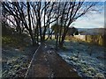
Leaving Pappert Well Community Woodland
In this, the opposite view to Image, the path is shown leading to the upper edge of the Beechwood Estate, close to its boundary with Braehead, one of the subdivisions of what is sometimes referred to as New Bonhill.
Image: © Lairich Rig
Taken: 11 Dec 2017
0.08 miles
5
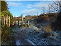
Entering Pappert Well Community Woodland
This point of access from the upper edge of the Beechwood Estate is at the south-western extremity of the community woodland. See Image for the opposite view.
See also Image, a short distance to the north.
Image: © Lairich Rig
Taken: 11 Dec 2017
0.09 miles
6

Entering Pappert Well Community Woodland
Another entrance is nearby, at the south-western extremity of the community woodland: Image It leads to the upper edge of the Beechwood Estate.
The one shown in the present picture is only a few metres to the north of it but, because of various quirks of the layout of the housing here, it leads instead to the upper edge of Braehead, one of the subdivisions of what is sometimes referred to as New Bonhill.
In fact, that difference is what accounts for there being two points of entry into the community woodland that are so close together.
Image: © Lairich Rig
Taken: 11 Dec 2017
0.10 miles
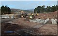
7
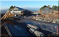
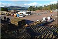
Bonhill High Dykes Development
Housing is being built on the former site of Highdykes Primary School. The large sign uses the spelling "High Dykes" (with a space) for the development. The nearby farm is called Highdykes: Image
See Image and Image for views from the other side.
Highdykes is the name of a nearby farm: Image The Blaeu map of the Lennox (1654, but based on earlier surveys from c.1600) shows it as Headdycks, but it has its present-day spelling of Highdykes on Roy's Military Survey of Scotland (c.1740s-50s).
Image: © Lairich Rig
Taken: 15 Oct 2020
0.11 miles
8
Bonhill High Dykes Development
The view is equivalent to Image, but six weeks later.
Image: © Lairich Rig
Taken: 28 Nov 2020
0.12 miles
10
Bonhill High Dykes Development
See Image for an equivalent view six weeks later.
Image: © Lairich Rig
Taken: 15 Oct 2020
0.12 miles