IMAGES TAKEN NEAR TO
Redburn, ALEXANDRIA, G83 9BX
Introduction
This page details the photographs taken nearby to Redburn, G83 9BX by members of the Geograph project.
The Geograph project started in 2005 with the aim of publishing, organising and preserving representative images for every square kilometre of Great Britain, Ireland and the Isle of Man.

There are currently over 7.5m images from over14,400 individuals and you can help contribute to the project by visiting https://www.geograph.org.uk
Image Map
Images are licensed for reuse under creativecommons.org/licenses/by-sa/2.0
Notes
- Clicking on the map will re-center to the selected point.
- The higher the marker number, the further away the image location is from the centre of the postcode.
Image Listing (22 Images Found)
Images are licensed for reuse under creativecommons.org/licenses/by-sa/2.0
Image
Details
Distance
1
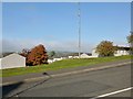
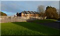
Covered reservoir, Redburn
There are a couple of small wrought-iron chimney-like objects beside the access hatch; they are reservoir ventilators.
The Redburn area is named after the Red Burn, which, confusingly, is not the one that flows through it (Image), but a different one further south (Image), whose course defined the boundary between Bonhill Parish and Dumbarton Parish.
Image: © Lairich Rig
Taken: 10 Oct 2012
0.11 miles
2
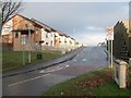
The entrance of St Ronan's (housing estate)
This housing estate in Nobleston, seen here from its entrance, is called St Ronan's, and was built in 2006. However, St Ronan's Primary School, a few hundred metres to the north, pre-dates this estate.
Image: © Lairich Rig
Taken: 28 Nov 2008
0.12 miles
3
Bonhill Community Garden
This was a recent initiative; the garden was created in 2018.
Image: © Lairich Rig
Taken: 23 Dec 2018
0.17 miles
4
Road leading into Beechwood and Wheatcroft
The road branching off to the right is Image, which leads into the Beechwood and Wheatcroft Estates.
Image: © Lairich Rig
Taken: 5 Oct 2012
0.19 miles
5
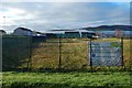
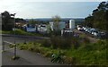
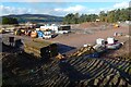
Bonhill High Dykes Development
This fence marks the lower (western) edge of the construction site.
Image: © Lairich Rig
Taken: 12 Dec 2020
0.20 miles
6
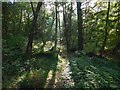
Woods near Nobleston: Croft Huggan
Some of the mist that had filled the Leven and Clyde valleys earlier in the morning lingered here.
The name Croft Huggan is applied to this area of woodland on large-scale mapping. Roy's Military Survey of Scotland (mid-eighteenth century) makes the origin of the name clear: there used to be a farm called Crofthoggan nearby.
Image: © Lairich Rig
Taken: 16 Oct 2015
0.20 miles
7
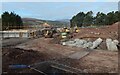
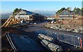
Bonhill High Dykes Development
Housing is being built on the former site of Highdykes Primary School. The large sign uses the spelling "High Dykes" (with a space) for the development. The nearby farm is called Highdykes: Image
See Image and Image for views from the other side.
Highdykes is the name of a nearby farm: Image The Blaeu map of the Lennox (1654, but based on earlier surveys from c.1600) shows it as Headdycks, but it has its present-day spelling of Highdykes on Roy's Military Survey of Scotland (c.1740s-50s).
Image: © Lairich Rig
Taken: 15 Oct 2020
0.20 miles
8
Bonhill High Dykes Development
See Image for an equivalent view six weeks later.
Image: © Lairich Rig
Taken: 15 Oct 2020
0.20 miles
10
Bonhill High Dykes Development
The view is equivalent to Image, but six weeks later.
Image: © Lairich Rig
Taken: 28 Nov 2020
0.20 miles