IMAGES TAKEN NEAR TO
Redburn, ALEXANDRIA, G83 9BP
Introduction
This page details the photographs taken nearby to Redburn, G83 9BP by members of the Geograph project.
The Geograph project started in 2005 with the aim of publishing, organising and preserving representative images for every square kilometre of Great Britain, Ireland and the Isle of Man.

There are currently over 7.5m images from over14,400 individuals and you can help contribute to the project by visiting https://www.geograph.org.uk
Image Map
Images are licensed for reuse under creativecommons.org/licenses/by-sa/2.0
Notes
- Clicking on the map will re-center to the selected point.
- The higher the marker number, the further away the image location is from the centre of the postcode.
Image Listing (26 Images Found)
Images are licensed for reuse under creativecommons.org/licenses/by-sa/2.0
Image
Details
Distance
1
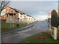
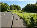
The entrance of St Ronan's (housing estate)
This housing estate in Nobleston, seen here from its entrance, is called St Ronan's, and was built in 2006. However, St Ronan's Primary School, a few hundred metres to the north, pre-dates this estate.
Image: © Lairich Rig
Taken: 28 Nov 2008
0.07 miles
2
Covered reservoir, Redburn
There are a couple of small wrought-iron chimney-like objects beside the access hatch; they are reservoir ventilators.
The Redburn area is named after the Red Burn, which, confusingly, is not the one that flows through it (Image), but a different one further south (Image), whose course defined the boundary between Bonhill Parish and Dumbarton Parish.
Image: © Lairich Rig
Taken: 10 Oct 2012
0.13 miles
3
Woods near Nobleston: Croft Huggan
Some of the mist that had filled the Leven and Clyde valleys earlier in the morning lingered here.
The name Croft Huggan is applied to this area of woodland on large-scale mapping. Roy's Military Survey of Scotland (mid-eighteenth century) makes the origin of the name clear: there used to be a farm called Crofthoggan nearby.
Image: © Lairich Rig
Taken: 16 Oct 2015
0.14 miles
4
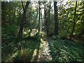
Woodland path near Nobleston
This footpath begins on the southern side of a main road that leads up into Nobleston.
Image: © Lairich Rig
Taken: 28 Nov 2008
0.15 miles
5
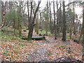
A new path from Mill Fields
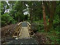
The path, which begins at the northern end of the upper level of housing at Mill Fields (still under construction when this picture was taken), passes through this area of woodland, in which it crosses the Red Burn, and emerges to meet the main road that runs along the southern edge of Nobleston.
At the time of submission, the housing development and the path were very recent, and were not yet marked on the OS map.
See Image for a view in the opposite direction.
Image: © Lairich Rig
Taken: 17 Jun 2018
0.15 miles
6
A new path to Mill Fields
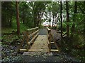
The path, which begins beside the main road that runs along the southern edge of Nobleston, passes through this area of woodland, in which it crosses the Red Burn, and leads to the upper level of the new housing development at Mill Fields (still under construction when this picture was taken): Image / Image
At the time of submission, the housing development and the path were very recent, and were not yet marked on the OS map.
See Image for a view in the opposite direction.
Image: © Lairich Rig
Taken: 15 Jun 2018
0.17 miles
7
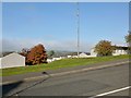
Road leading into Beechwood and Wheatcroft
The road branching off to the right is Image, which leads into the Beechwood and Wheatcroft Estates.
Image: © Lairich Rig
Taken: 5 Oct 2012
0.17 miles
8
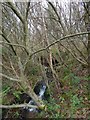
The Red Burn
This is the burn as seen from the pavement beside the road leading up into Nobleston. As the first-edition OS maps (surveyed in 1860) show, the course of this burn was part of the boundary between the parishes of Bonhill and Dumbarton.
Image: © Lairich Rig
Taken: 17 Mar 2014
0.20 miles
9
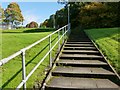
Steps leading up to Nobleston
The steps lead up from Stirling Road. The large area of housing on the hillside is divided into several areas; the part at the top of the steps is Nobleston, derived from the older designation Bonhill-Noble; for example, a retour of Charles II speaks of the lands of "Bonyle Noble alias Noblestoune" (*).
There was also a Bonhill-Napier and a Bonhill-Lindsay; they are mentioned in the same retour (as "Bonyle Naiper" and "Bonyle Lindsay"). Each of the three lands was named after the family who held it. According to page 152 of Donald MacLeod's "Historic Families ... of the Lennox" (1891), Bonhill-Noble was in the hands of the Nobles of Ardardan, a family prominent in the area.
As is explained at Image, the name Bonhill-Napier refers to the Napiers of Kilmahew. Finally, the name Bonhill-Lindsay reflects the fact that Patrick de Lindsay had been granted lands in Bonhill by Malcolm, Earl of Lennox (early fourteenth century).
(*) The retour can be found on pages 100-102 of the Lennox Cartulary ["Cartularium Comitatus de Levenax, etc." (1833), Maitland Club Edition], a collection of charters in medieval Latin. For the grants made to "Patricio de Lindsay", whom Malcolm created a hereditary bailie and forester of the Lennox estate, see pages 49-52 of the same work.
Image: © Lairich Rig
Taken: 5 Oct 2012
0.20 miles
10
Junction, Bonhill signage
Stirling Road A813 looking north, Junction to Main Street Bonhill left of Bonhill signage, Stirling Road continues northward beyond Bonhill signage. Nobleston Estate on top right of photograph.
Image: © George Rankin
Taken: 6 Aug 2019
0.21 miles