IMAGES TAKEN NEAR TO
Scott Street, ALEXANDRIA, G83 9AS
Introduction
This page details the photographs taken nearby to Scott Street, G83 9AS by members of the Geograph project.
The Geograph project started in 2005 with the aim of publishing, organising and preserving representative images for every square kilometre of Great Britain, Ireland and the Isle of Man.

There are currently over 7.5m images from over14,400 individuals and you can help contribute to the project by visiting https://www.geograph.org.uk
Image Map
Images are licensed for reuse under creativecommons.org/licenses/by-sa/2.0
Notes
- Clicking on the map will re-center to the selected point.
- The higher the marker number, the further away the image location is from the centre of the postcode.
Image Listing (62 Images Found)
Images are licensed for reuse under creativecommons.org/licenses/by-sa/2.0
Image
Details
Distance
1
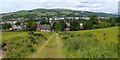
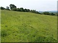
Track from site of Northfield Cottage
This track would have provided access to Northfield Cottage when the latter was still standing (Image), but it is now simply a farm track. Downhill, at the edge of the field, are the backs of the houses on Hillbank Street (to the left) and its continuation, Northfield Road (to the right). They more or less correspond to the old Slunger Hill Road (in popular usage, simply "the Slunger"), on which, see Image
Background details include Image on the skyline, left of centre, and the tower of Image on the right (best seen in larger image sizes).
See also Image, a similar view but taken from further uphill (in the adjacent grid square to the east).
Image: © Lairich Rig
Taken: 25 Jun 2012
0.04 miles
2
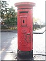
Edwardian pillar box
This is located at the junction of Burn Street and Dalmonach Road. The pavement visible in the background, to the right of the pillar box, is that of Burn Street.
Image: © Lairich Rig
Taken: 28 Nov 2008
0.05 miles
3
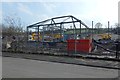
Construction in Dalmonach
This is a view, from Second Avenue, of the construction of Dalmonach Community Centre and Early Learning Centre.
Image: © Lairich Rig
Taken: 5 Apr 2019
0.07 miles
4
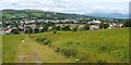
Track from site of Northfield Cottage
This is a view downhill along the same track as shown in Image, but the present photograph was taken from several hundred metres further uphill. Part of Loch Lomond can be seen on the right. Also visible on the right in this image is a large industrial building with the tall chimney: Image
Not far ahead, just beyond the white tub, an old field boundary cuts across the track; its former course is still evident on the right as a line of trees, but it is less visible to the left of the track: Image
For an uphill view along the track, see Image
Image: © Lairich Rig
Taken: 25 Jun 2012
0.11 miles
5
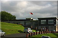
Vale of Leven Golf Club
Vale of Leven Golf Club was founded in 1907. Situated in Bonhill Alexandria, close to Loch Lomond, it boasts an 18 hole course with around 700 members.
Image: © George Rankin
Taken: 25 Jun 2007
0.11 miles
6
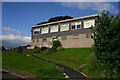
Vale of Leven Golf Club Side View
Vale of Leven Golf Club founded 1907
Image: © George Rankin
Taken: 25 Jun 2007
0.13 miles
7
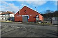
Leven Street Motors, Bonhill
This garage is on Burn Street, opposite the junction with Hall Street. The building had been used as a drill hall during the First World War.
See Image for a view from another angle, and Image for one from further away.
Another contributor's article provides a useful listing of sites that were used as drill halls during the First World War: http://www.geograph.org.uk/article/WW1-Great-War-Centenary---Drill-Halls
Image: © Lairich Rig
Taken: 14 Feb 2016
0.15 miles
8
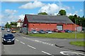
Leven Street Motors, Bonhill
This large building at the junction of Burn Street (shown on the left) and Hillbank Street is now used as a garage, but it served as a drill hall during the First World War: see https://canmore.org.uk/site/332989/bonhill-burn-street-drill-hall (at Canmore).
For a view from the front of the building, see Image For a slightly more distant view, with context, see Image
Another contributor's article provides a useful listing of sites that were used as drill halls during the First World War: http://www.geograph.org.uk/article/WW1-Great-War-Centenary---Drill-Halls
Burn Street is so called because a burn used to flow along it: Image
Image: © Lairich Rig
Taken: 21 May 2014
0.15 miles
9
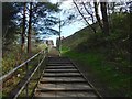
Steps to Dalmonach Road
The path leads up from Main Road near the eastern end of the Image
Image: © Lairich Rig
Taken: 5 Apr 2019
0.15 miles
10
Former field boundary
This is the area to the left (south) of the track that is shown in Image In the present photograph, the course of an old field boundary recedes directly into the distance from the lower right corner of the picture. This former boundary is not now very obvious in a photograph (although, at the time of writing, it is still depicted on large-scale OS mapping).
The trees in the background are situated alongside the course of the Pappert Burn (see the map).
Image: © Lairich Rig
Taken: 25 Jun 2012
0.15 miles