IMAGES TAKEN NEAR TO
Gartocharn, ALEXANDRIA, G83 8NQ
Introduction
This page details the photographs taken nearby to G83 8NQ by members of the Geograph project.
The Geograph project started in 2005 with the aim of publishing, organising and preserving representative images for every square kilometre of Great Britain, Ireland and the Isle of Man.

There are currently over 7.5m images from over14,400 individuals and you can help contribute to the project by visiting https://www.geograph.org.uk
Image Map
Images are licensed for reuse under creativecommons.org/licenses/by-sa/2.0
Notes
- Clicking on the map will re-center to the selected point.
- The higher the marker number, the further away the image location is from the centre of the postcode.
Image Listing (22 Images Found)
Images are licensed for reuse under creativecommons.org/licenses/by-sa/2.0
Image
Details
Distance
1
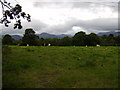
Cattle grazing in field near Loch Lomond
At Gartochraggan.
Image: © Stephen Sweeney
Taken: 30 Aug 2007
0.09 miles
2
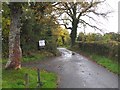
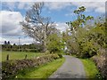
Route to Loch Lomond National Nature Reserve
A private road for access to several houses, also a walking route to the nature reserve on the south shore of Loch Lomond.
Image: © Jim Barton
Taken: 17 Oct 2012
0.09 miles
3
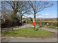
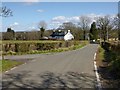
Townhead of Aber
In his booklet "Off the Main Road" (1976), I M M MacPhail wrote about the Townhead of Aber, and its pillar-box, which seemed "quaintly out of place in its rural setting". It presumably stood here, where there is now a more modest postbox. MacPhail also notes that few houses in Aber are contiguous with one another, but that the Townhead was regarded as a central point.
The name Townhead of Aber can be seen on the first-edition OS map (surveyed in 1860), and appears on subsequent OS maps until around 1960.
See also Image, where part of the same area is visible in the left foreground. That item also comments on the name Aber itself.
Image: © Lairich Rig
Taken: 19 Apr 2013
0.11 miles
4
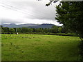
View to Conic Hill from Gartochraggan
From a field near Gartochraggan.
Image: © Stephen Sweeney
Taken: 30 Aug 2007
0.12 miles
5
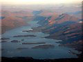
Loch Lomond from the air
The River Endrick (or Endrick Water) can be seen in the lower right corner. Ben Lomond can be seen on the right bank of the loch with numerous peaks beyond.
Image: © Thomas Nugent
Taken: 18 Nov 2018
0.12 miles
6
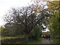
An ancient yew tree, Loch Lomond National Nature Reserve
An old yew by the road to the nature reserve.
Image: © Jim Barton
Taken: 17 Oct 2012
0.13 miles
7
Aber
This is a view from what used to be known as the Image
Simon Taylor, in his chapter in the book "Changing Identities, Ancient Roots", points out that the place-name Aber "looks deceptively British". The British element "Aber" refers to a confluence, but since that element is otherwise unknown in place-names in this area, the Aber shown in my picture is thought (see the work just cited) to be named, instead, from the Gaelic "eabar" (pool, puddle, marsh, mire, etc.), on account on the extensive bog nearby (centred on Image).
There is also an Aber Isle (Image); the isle is not far offshore from Aber itself, and presumably was named after it.
Image: © Lairich Rig
Taken: 19 Apr 2013
0.13 miles
8
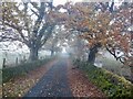
Approaching Aber
In this picture, taken on the Aber Path, the building that is visible indistinctly through the trees is the same one as appears in a picture of Image
Image: © Lairich Rig
Taken: 17 May 2013
0.15 miles
10
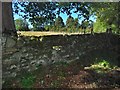
Stile in a wall
I did not cross the wall, which separates the road from a plantation, but simply stopped to look at this feature. Some dry-stone walls have through-stones in them, and this one did have a few of those, but what is shown here is a stile built into the wall. Steps are probably only present on this side, since the ground is higher on the other side.
Image: © Lairich Rig
Taken: 20 Sep 2019
0.17 miles