IMAGES TAKEN NEAR TO
Cumbrae Crescent South, DUMBARTON, G82 5AR
Introduction
This page details the photographs taken nearby to Cumbrae Crescent South, G82 5AR by members of the Geograph project.
The Geograph project started in 2005 with the aim of publishing, organising and preserving representative images for every square kilometre of Great Britain, Ireland and the Isle of Man.

There are currently over 7.5m images from over14,400 individuals and you can help contribute to the project by visiting https://www.geograph.org.uk
Image Map
Images are licensed for reuse under creativecommons.org/licenses/by-sa/2.0
Notes
- Clicking on the map will re-center to the selected point.
- The higher the marker number, the further away the image location is from the centre of the postcode.
Image Listing (73 Images Found)
Images are licensed for reuse under creativecommons.org/licenses/by-sa/2.0
Image
Details
Distance
1
Perray Avenue, Hawthornhill
Perray Avenue is a short street attached to the northern side of Hawthornhill Road. About 350 metres to the west are the similarly-named Perrays Way, Drive, Crescent, Grove, and Court.
About 600 metres to the north-west of the point where the photograph was taken is a small square of woodland (Image) called Perrays Wood (visible on the left in Image); this makes the origin of all of these street names clear.
The same Image is mentioned in David Murray's book "Old Cardross: a lecture" (1880), where it is described as "the wood about halfway between Kellochy and Hawthornhill" (Kellochy, now long gone, was at Image; for Hawthornhill, see Image).
The same work adds that "The Perrays" were "the two fields on the north of Hawthornhill, on the east and west of the road to Ardochbeg" (on which, see Image).
Image: © Lairich Rig
Taken: 24 Dec 2010
0.06 miles
2
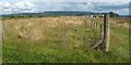
Corner of enclosure
This fenced-off rectangular enclosure, measuring 90 metres by 25, is located just to the west of Knowetop Farm.
For the background hills, see Image; at the right-hand edge of the escarpment, behind a tree and a purple-pink patch of Rosebay Willowherb, is distant Image
Image: © Lairich Rig
Taken: 3 Jun 2009
0.06 miles
3
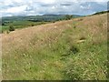
Path near Knowetop Farm
This short path has been made by people walking between Cumbrae Crescent South and Knowetop Farm; the farm lies ahead, but is hidden from view by the foreground rise.
Situated centrally on the skyline is the escarpment of the Kilpatrick Hills; the single peak at their left-hand end is Doughnot Hill (Image).
For the view in the opposite direction, see Image
Image: © Lairich Rig
Taken: 15 Jul 2009
0.07 miles
4
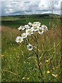
Sneezewort (Achillea ptarmica)
This is a common flower, found in damp grassy places.
Its flowers are quite similar to those of Yarrow (A. millefolium), but the finely dissected leaves of the latter are very different: Image
Carman Hill is visible, right of centre, in the background.
[Regarding the common name of this plant, the OED comments that its dried leaves were "powdered and used as a sternutatory" (i.e., to induce sneezing, for its supposed medical benefits). The specific name "ptarmica" is from Gk. "πταρμικός" (ptarmikós: "causing to sneeze"). Any similarity to "ptarmigan", the bird, is accidental; the latter word is entirely unrelated, and is from the Gaelic "tarmachan".]
Image: © Lairich Rig
Taken: 15 Jul 2009
0.08 miles
5
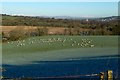
Field near Castlehill
The tower of Image can be seen on the right, with snow-covered Ben Ledi (Image, 38km / 24 miles) behind it. At the centre of the skyline is Gualann (Image, 20km / 12 miles), with less snow.
Image: © Lairich Rig
Taken: 8 Jan 2018
0.09 miles
6
Dalreoch United Free Church of Scotland
Another contributor's earlier (2011) picture: Image
Image: © Lairich Rig
Taken: 7 Jun 2020
0.09 miles
7
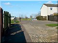
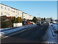
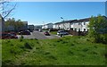
Cumbrae Crescent South, Hawthornhill
This is the western end of the street; for the other end, see Image
This area is also part of a core path from Hawthornhill to Dalmoak. That route leads uphill from Cardross Road (see Image), then cuts through Image to emerge at the point from which the present photograph was taken. It then continues directly ahead, leaving Hawthornhill by means of the western end of Cumbrae Crescent South, just left of the centre of the photo.
At that point, the route leaves the built-up area behind; for the view from that spot, see Image
Image: © Lairich Rig
Taken: 24 Mar 2011
0.09 miles
8
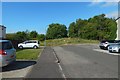
Path at Hawthornhill
The view is the one obtained by turning left just after the point shown in Image For a view from about 70 metres further along this path, see Image, where the route to Dalmoak that is mentioned in the end-note leaves the area of housing.
Image: © Lairich Rig
Taken: 13 Jul 2018
0.09 miles
9
Heading to Hawthornhill
After following the side of a hedge (Image) and then ascending a grassy slope, the route enters a built-up area here at Cumbrae Crescent South.
Image: © Lairich Rig
Taken: 6 May 2020
0.10 miles
10
Path at Hawthornhill
The view is from about 70 metres further along the path shown in Image, continuing in the same direction.
At this point, the route to Dalmoak that is mentioned in the end-note leaves the area of housing, and carries on straight ahead, through a gap in the trees. It then leads down a slope, as shown in Image
Image: © Lairich Rig
Taken: 13 Jul 2018
0.10 miles