IMAGES TAKEN NEAR TO
Keil Crescent, DUMBARTON, G82 4DU
Introduction
This page details the photographs taken nearby to Keil Crescent, G82 4DU by members of the Geograph project.
The Geograph project started in 2005 with the aim of publishing, organising and preserving representative images for every square kilometre of Great Britain, Ireland and the Isle of Man.

There are currently over 7.5m images from over14,400 individuals and you can help contribute to the project by visiting https://www.geograph.org.uk
Image Map
Images are licensed for reuse under creativecommons.org/licenses/by-sa/2.0
Notes
- Clicking on the map will re-center to the selected point.
- The higher the marker number, the further away the image location is from the centre of the postcode.
Image Listing (47 Images Found)
Images are licensed for reuse under creativecommons.org/licenses/by-sa/2.0
Image
Details
Distance
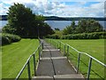
1
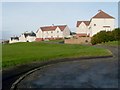
Firthview Terrace, Brucehill
The viewpoint is a few metres from the top of the steps shown here: Image For the grassy area to the left of the houses, see Image
Image: © Lairich Rig
Taken: 21 Nov 2008
0.04 miles
2
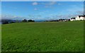
Playing field at Brucehill
This area is to the left (northwest) of the top of the flight of steps shown in Image For the houses on the right, see Image
Image: © Lairich Rig
Taken: 27 Oct 2017
0.04 miles
3
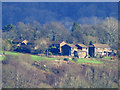
Oxhill Place, Dumbarton
Viewed from Newark Castle Park, Port Glasgow.
Image: © Thomas Nugent
Taken: 8 Feb 2016
0.06 miles
4
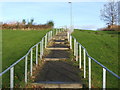
Steps leading up to Brucehill
These steps form the last part of the footpath shown here: Image
They lead to the corner of Firthview Terrace and Keil Crescent: Image
For a view down the same steps, see Image
Image: © Lairich Rig
Taken: 21 Nov 2008
0.08 miles
5
Steps leading down from Brucehill
The subject is as in Image, but the view is in the opposite direction.
Followed downhill, as shown in the present picture, the path continues as shown in Image, and leads down to the Shore Circular Path.
Image: © Lairich Rig
Taken: 29 Jul 2015
0.09 miles
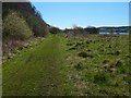
6

Path in Havoc Grassland
The trees to the left hide a line of cliffs, and wild flowers cover the raised beach on the right. See Image for a view in the opposite direction from the same place.
Image: © Lairich Rig
Taken: 21 Jul 2017
0.11 miles
7
Brucehill Cliffs and Havoc Grassland
The cliffs, on the left, are hidden for much of their length by trees. A house visible ahead is part of the Keil Mansions development (see Image).
Image: © Lairich Rig
Taken: 20 Apr 2016
0.11 miles
8
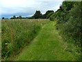
Path in Havoc Grassland
The trees on the right hide a line of cliffs, and wild flowers cover the raised beach to the left. See Image for a view in the opposite direction from the same place.
Image: © Lairich Rig
Taken: 21 Jul 2017
0.11 miles
9
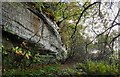
Cliffs at Brucehill
The map shows a bunching a contour lines here (the cliffs), and a flat area in front. The flat area is a raised beach, and these cliffs were once sea-cliffs (Image / Image).
From a distance, the rock face shown here is screened by trees (compare Image). Dripping water keeps the surface damp, creating a home for liverworts and ferns such as Royal Fern (see Image).
See Image for a view in the opposite direction.
Image: © Lairich Rig
Taken: 27 Oct 2017
0.12 miles
10
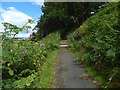
Path to Brucehill
Beyond the flight of steps visible ahead among the trees, the path continues as more steps (Image), leading up to Image
The exposed rock to the right of the path (Image) is a reminder that this path leads up what were once sea cliffs; see Image, and compare nearby Image and Image
For a view in the opposite direction (down the path), see Image
Image: © Lairich Rig
Taken: 29 Jul 2015
0.12 miles