IMAGES TAKEN NEAR TO
Lomond Court, West Bridgend, DUMBARTON, G82 4BU
Introduction
This page details the photographs taken nearby to Lomond Court, West Bridgend, G82 4BU by members of the Geograph project.
The Geograph project started in 2005 with the aim of publishing, organising and preserving representative images for every square kilometre of Great Britain, Ireland and the Isle of Man.

There are currently over 7.5m images from over14,400 individuals and you can help contribute to the project by visiting https://www.geograph.org.uk
Image Map (Loading...)


Getting Data...Please wait
Leaflet Map data © OpenStreetMap
Images are licensed for reuse under creativecommons.org/licenses/by-sa/2.0
Notes
- Clicking on the map will re-center to the selected point.
- The higher the marker number, the further away the image location is from the centre of the postcode.
Image Listing (199 Images Found)
Images are licensed for reuse under creativecommons.org/licenses/by-sa/2.0
Image
Details
Distance
1

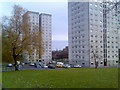
The high flats at West Bridgend
From left to right, they are: Clyde Court, Lomond Court, and Leven Court. See Image for their earlier appearance, and Image for another view of them in their present colour-scheme.
Image: © Lairich Rig
Taken: 1 Feb 2012
0.00 miles
2
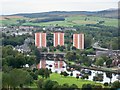
High flats in Dumbarton
On the site of the former Dennystown area.
Image: © Stephen Sweeney
Taken: 25 Nov 2007
0.02 miles
3
High rise housing, Dennystown
With a view to Dumbarton Rock.
Image: © Barbara Carr
Taken: 18 Apr 2013
0.02 miles
4
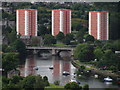
West Bridgend And The River Leven
The three multi-storey blocks of flats at West Bridgend are prominent in this shot taken from White Tower Craig, Dumbarton Rock.
Image: © James T M Towill
Taken: 4 Sep 2011
0.02 miles
5
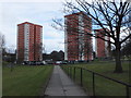
The high flats at West Bridgend
From left to right: Clyde Court, Lomond Court, Leven Court.
By the end of 2011, after some repairs, and the installation of insulated overcladding, all three flats had a different colour-scheme: see Image and Image
Image: © Lairich Rig
Taken: 19 Aug 2008
0.03 miles
6
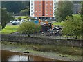
Demolition of West Bridgend Community Centre
The view is from Image For more context, see Image
In the present view, the rubble from the community centre is directly in front of Clyde Court, one of Image
For a view of the demolition site from another angle, and for further information, see Image
Image: © Lairich Rig
Taken: 26 Sep 2017
0.04 miles
7
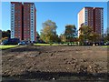
The cleared site of West Bridgend Community Centre
The Community Centre is shown intact in an earlier picture (Image), and being cleared away in Image and Image, leaving the site as shown here. It was originally intended that a new community centre be built in the same place, but by early 2019 the site was grassed over.
There are three high flats at West Bridgend: Image The ones in the present picture are Clyde Court (left) and Lomond Court. Leven Court is out of shot to the right.
Image: © Lairich Rig
Taken: 2 Nov 2017
0.04 miles
8
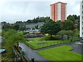
Beside the West Bridgend high flats
The view is from Image For the high flats, see Image In the left foreground is the footpath / cycle path, part of NCN Route 7 (Image).
Just beyond the play area was West Bridgend Community Centre, which was being demolished when this picture was taken: for closer views, see Image and Image
Image: © Lairich Rig
Taken: 25 Sep 2017
0.04 miles
9
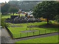
Demolition of West Bridgend Community Centre
The view is from Image For more context, see Image, taken a day earlier.
The community centre had been deemed unsafe, and was being demolished.
The picture was taken on a Tuesday; for a view from a different angle on the same day, see Image By the weekend, everything above ground level had been cleared away: Image
For pictures showing or including the community centre before it was demolished, see Image / Image / Image / Image
It was originally intended that a new community centre be built in the same place, but by early 2019 the site was grassed over.
Image: © Lairich Rig
Taken: 26 Sep 2017
0.04 miles
10
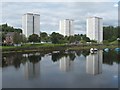
View from Dumbarton Rock towards Dumbarton Bridge & Clyde & Lomond Courts
Image: © Colin Park
Taken: 6 Jun 2012
0.05 miles