IMAGES TAKEN NEAR TO
Helenslee Road, DUMBARTON, G82 4BS
Introduction
This page details the photographs taken nearby to Helenslee Road, G82 4BS by members of the Geograph project.
The Geograph project started in 2005 with the aim of publishing, organising and preserving representative images for every square kilometre of Great Britain, Ireland and the Isle of Man.

There are currently over 7.5m images from over14,400 individuals and you can help contribute to the project by visiting https://www.geograph.org.uk
Image Map
Images are licensed for reuse under creativecommons.org/licenses/by-sa/2.0
Notes
- Clicking on the map will re-center to the selected point.
- The higher the marker number, the further away the image location is from the centre of the postcode.
Image Listing (56 Images Found)
Images are licensed for reuse under creativecommons.org/licenses/by-sa/2.0
Image
Details
Distance
1
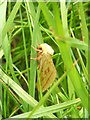
Ghost Moth (Hepialus humuli)
This is a female. The males are coloured rather differently, being predominantly white.
Image: © Lairich Rig
Taken: 14 Jun 2005
0.03 miles
2
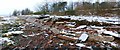
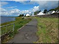
The Shore Circular Path (damaged)
At the top of the embankment is one of the area's core paths; the section shown here is about 90 metres further along the route that is shown in Image Winds of up to 80 mph have driven the waters of the River Clyde against the embankment, destroying this part of it, and undermining the path's tarmac. Before the storm, many days of heavy rain had already caused flooding in other parts of the town.
For a later view of this part of the route, see Image
For damage elsewhere on the same path, see Image
Image: © Lairich Rig
Taken: 16 Dec 2011
0.03 miles
3
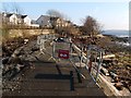
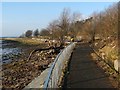
Footpath under repair
This section of the Shore Circular Path was severely damaged by storms: Image Pedestrians were directed around the damaged area, so that the path could still be used while repairs were being made.
For the houses in the background, see Image
Image: © Lairich Rig
Taken: 30 Jan 2012
0.04 miles
4
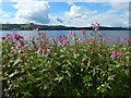
Himalayan Balsam
(Impatiens glandulifera)
Another of its common names is Image; see that item for more information.
The patch shown in the present picture is beside Image, and it can be seen, not far ahead, in that picture.
Image: © Lairich Rig
Taken: 29 Jul 2015
0.04 miles
5
The Shore Circular Path
The houses appeared only recently, as can be seen by comparing a picture taken a few years earlier from roughly the same place: Image
A patch of Image can be seen not far ahead, where the path changes direction.
(For the houses, see Image and Image)
Image: © Lairich Rig
Taken: 29 Jul 2015
0.04 miles
6
The Shore Circular Path
At this time, part of the path had recently been damaged by storms and was being repaired: Image
Just a few years later, houses occupied the area to the right (north) of the path; see Image, taken from almost the same place as the present picture.
Image: © Lairich Rig
Taken: 30 Jan 2012
0.05 miles
7
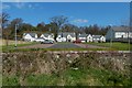
Houses in Keil Gardens
When this picture was submitted, the houses were recent, and were not yet shown in online mapping. The view is from the path at the head of the shore.
Image: © Lairich Rig
Taken: 9 Apr 2019
0.05 miles
8
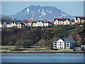
Ben Lomond and Dumbarton
The top of the ben seen behind houses in Brucehill. Viewed from Main Road, Langbank.
Image: © Thomas Nugent
Taken: 5 Apr 2015
0.07 miles
9
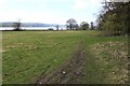
Former playing fields of Keil School
The field is bounded on the shore side by a wall; on the other side of the wall is a footpath, part of a shore-side route from Levengrove to Ardoch.
For the main description of Keil School, see Image At the time this photograph was taken, the school had been closed for a few years. By 2009, when this photograph was submitted, the fields shown here were being developed for new housing (Image); as a result, the view shown here no longer existed.
About halfway up the right-hand edge of the picture, a green track shows the location of the entrance of a former quarry: Image
Image: © Lairich Rig
Taken: 19 Apr 2005
0.08 miles
10
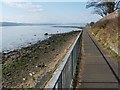
The Shore Circular Path
The route is part of West Dunbartonshire's network of core paths. This section provides fine views out into the Firth of Clyde. The notch, just right of centre, in the distant line of hills marks the course of Glen Lean (Image), which is about 30 kilometres away.
The wall to the right of the path encloses Image
Image: © Lairich Rig
Taken: 24 Mar 2011
0.08 miles