IMAGES TAKEN NEAR TO
Gleddoch View, DUMBARTON, G82 4BL
Introduction
This page details the photographs taken nearby to Gleddoch View, G82 4BL by members of the Geograph project.
The Geograph project started in 2005 with the aim of publishing, organising and preserving representative images for every square kilometre of Great Britain, Ireland and the Isle of Man.

There are currently over 7.5m images from over14,400 individuals and you can help contribute to the project by visiting https://www.geograph.org.uk
Image Map (Loading...)


Getting Data...Please wait
Leaflet Map data © OpenStreetMap
Images are licensed for reuse under creativecommons.org/licenses/by-sa/2.0
Notes
- Clicking on the map will re-center to the selected point.
- The higher the marker number, the further away the image location is from the centre of the postcode.
Image Listing (90 Images Found)
Images are licensed for reuse under creativecommons.org/licenses/by-sa/2.0
Image
Details
Distance
1
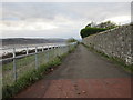
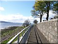
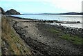
Shoreline path below Kirktonhill
The wall on the right bounded the grounds of Methlan Park, a substantial house now demolished and replaced with suburban housing.
Image: © Jonathan Thacker
Taken: 2 Nov 2017
0.03 miles
2
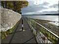
Path west from Levengrove Park
Leads along the riverfront in the direction of Cardross.
Image: © Stephen Sweeney
Taken: 5 May 2008
0.03 miles
3
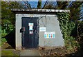
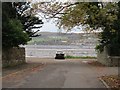
Methlan Park WWPS
The waste water pumping station is behind the iron gate that is shown on the right in Image and on the left in Image
Image: © Lairich Rig
Taken: 29 Mar 2018
0.03 miles
4
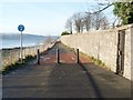
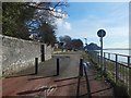
The Shore Circular Path (from Clydeshore Road)
This photograph was taken from exactly the same place (but facing in the opposite direction) as this one: Image
When following this route, there is the option of leaving the shore at more than one place, depending on the length of Circular Path desired: either at Havoc Road (Image), or, a little further on, at a point beside a sewage works (Image). It is also possible to continue further along the shoreline, following a right of way to Ardoch (Image); this soon becomes impassable for cyclists, but pedestrians can walk along the beach (tide allowing).
The locked gate visible in this photograph provides access to a water pumping station: Image See Image for a view in the opposite direction along the path.
Image: © Lairich Rig
Taken: 3 Dec 2008
0.03 miles
6
The Shore Circular Path
The subject is as in Image, but the view is in the opposite direction.
Not far ahead, though hidden by the wall and the curve in the path, are Image, and the foot of Clydeshore Road.
Image: © Lairich Rig
Taken: 23 Oct 2015
0.04 miles
7
The end of Clyde Shore Road
Looking across the Clyde to Langbank.
Image: © Jonathan Thacker
Taken: 2 Nov 2017
0.04 miles
8
The Shore Circular Path
Image is behind the iron gate set in the wall on the left. Just beyond that is the foot of Clydeshore Road; the other end of that road is shown in Image The short row of houses directly ahead is Image (Image).
See Image for a view in the opposite direction.
Image: © Lairich Rig
Taken: 29 Mar 2018
0.04 miles
9
Old sewage outfall pipe
Old discharge pipe into the Clyde.
Image: © Richard Sutcliffe
Taken: 19 Nov 2022
0.04 miles
10
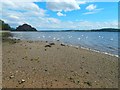
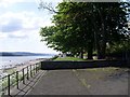
The Clyde shore at Levengrove
This part of the beach is near the foot of Clydeshore Road; the picture was taken from beside a Image
The swans shown here (and in the other view just linked) have drifted down from nearer to Dumbarton Rock, which can be seen in the background (compare Image). At the far left is the area shown in Image
Image: © Lairich Rig
Taken: 23 Jun 2016
0.05 miles