IMAGES TAKEN NEAR TO
Dixon Drive, DUMBARTON, G82 4AP
Introduction
This page details the photographs taken nearby to Dixon Drive, G82 4AP by members of the Geograph project.
The Geograph project started in 2005 with the aim of publishing, organising and preserving representative images for every square kilometre of Great Britain, Ireland and the Isle of Man.

There are currently over 7.5m images from over14,400 individuals and you can help contribute to the project by visiting https://www.geograph.org.uk
Image Map
Images are licensed for reuse under creativecommons.org/licenses/by-sa/2.0
Notes
- Clicking on the map will re-center to the selected point.
- The higher the marker number, the further away the image location is from the centre of the postcode.
Image Listing (144 Images Found)
Images are licensed for reuse under creativecommons.org/licenses/by-sa/2.0
Image
Details
Distance
1

Path to the shore
This is a view from the top of the path, alongside Dixon Drive. It leads downhill for about 230 metres; at the foot of the slope, it joins Image, as shown in Image
For a view from further ahead, about 5½ years later, see Image
Image: © Lairich Rig
Taken: 24 Mar 2011
0.07 miles
2
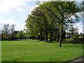
Western end of Levengrove Park
From the path through the park.
Image: © Stephen Sweeney
Taken: 5 May 2008
0.07 miles
4

Carmelite Monastery
This photograph was taken from Image The name "Carmelite Monastery" is shown on the entrance gates, which are located only a short distance further up the road.
The building, which is also known as Garmoyle House, was built in 1890. It is home to Carmelite Nuns. According to their own website, "The Carmelite Nuns are part of the Roman Catholic Church, belonging to the world-wide Order of the Discalced Carmelites".
"Garmoyle Light-ship floats due south from the mansion, and after the particular place which gives its name to it I presume the house is named" [Donald MacLeod, "Dumbarton Ancient and Modern" (1893), Chapter XXXVII].
There is a photograph of the Garmoyle Lightship on page 98 of John F Riddell's "Clyde Navigation" (1979); the caption mentions that it was replaced by a buoy in 1905.
Image: © Lairich Rig
Taken: 24 Mar 2011
0.08 miles
5
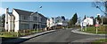
Keil Mansions
The houses shown here are part of a recent development on what had previously been the grounds of Keil School; for the main description of the school and its surroundings, see Image
The development is variously described on signs in the area; older ones say "Keil Mansions", and newer ones "The Mansions at Keil School", which seems to be the development's full name (at the time of writing). The road leading uphill in this photograph is Image, with Dixon Drive branching off to the right in the foreground.
For a view of another part of the same development, located just downhill from the part shown in my photograph, see Image, which was, coincidentally, taken on the previous day.
Image: © Lairich Rig
Taken: 24 Mar 2011
0.09 miles
6

Looking north along the path in Levengrove Park
Image: © Stephen Sweeney
Taken: 5 May 2008
0.09 miles
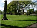
7

Pathway through the park
At the western side of the park.
Image: © Stephen Sweeney
Taken: 5 May 2008
0.10 miles
8
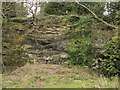
Quarry adjoining Keil School's playing field
The quarry shown here is surrounded by a wall of rock, except for an opening on the southern side that leads directly to the playing fields of Keil School (the school is now closed): Image
The quarry is cut into the cliffs of an ancient shoreline, now raised up.
Image: © Lairich Rig
Taken: 19 Apr 2005
0.11 miles
9
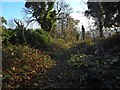
Path to the shore
The path is the one shown in Image, but the view is from further ahead. The path is becoming overgrown, but it is (at the time of writing) one of the local council's core paths (path 20, length 237 metres).
The far end of the path is shown in Image, from another path, one that runs parallel to the shore.
Image: © Lairich Rig
Taken: 4 Dec 2016
0.11 miles
10
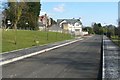
Keil Gardens
Keil Gardens is the name of the road. The buildings on the left are part of a housing development, some of it still under construction, called Keil Mansions (an exception is the darker building at the back, which is the Image; it lies outwith the housing development).
The grassy area on the left is the same one as appears on the right in Image (the two pictures were taken from roughly the same spot). The area occupied by the housing development was previously part of the grounds of the school; see the link just cited for further details. As mentioned there, a statue of Sir William Mackinnon used to stand on the grass here (it was brought here from Mombasa). After the school closed, the statue was relocated to Campbeltown.
Another building that used to be located on that grassy area was Mason House, which was one of several buildings that accommodated the school's boarding pupils. It was named after Mr Mason, the school's first headmaster.
Dumbarton Rock can be seen, on the right, in the background of the present photograph.
Image: © Lairich Rig
Taken: 24 Mar 2011
0.13 miles