IMAGES TAKEN NEAR TO
Overburn Avenue, DUMBARTON, G82 2RL
Introduction
This page details the photographs taken nearby to Overburn Avenue, G82 2RL by members of the Geograph project.
The Geograph project started in 2005 with the aim of publishing, organising and preserving representative images for every square kilometre of Great Britain, Ireland and the Isle of Man.

There are currently over 7.5m images from over14,400 individuals and you can help contribute to the project by visiting https://www.geograph.org.uk
Image Map
Images are licensed for reuse under creativecommons.org/licenses/by-sa/2.0
Notes
- Clicking on the map will re-center to the selected point.
- The higher the marker number, the further away the image location is from the centre of the postcode.
Image Listing (90 Images Found)
Images are licensed for reuse under creativecommons.org/licenses/by-sa/2.0
Image
Details
Distance
1
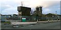
Concrete plant
Tarmac Ltd run this concrete plant, which is located beside Elm Road in Dumbarton's Broadmeadow Industrial Estate. Compare their plant in Greenock: Image
Image: © Lairich Rig
Taken: 1 Jan 2012
0.09 miles
2
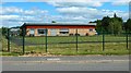
Brock Bowling Club
An earlier view: Image The Brock family were also remembered in the name of the Brock Baths, which stood where Image is now.
Image: © Lairich Rig
Taken: 3 Jun 2020
0.10 miles
3
Elm Road Depot
This council depot is located on the western side of Elm Road, in Broadmeadow Industrial Estate.
Image: © Lairich Rig
Taken: 1 Jan 2012
0.10 miles
4
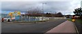
Poplar Road, Dumbarton
The photograph was taken from a point further along the road that is shown in Image In the present photograph, the premises on the left are those of Aggreko. For their new manufacturing plant, set to open in 2012, see Image
Image: © Lairich Rig
Taken: 1 Jan 2012
0.11 miles
5
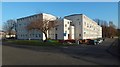
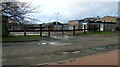
Overburn Avenue and Park Crescent
For the change in appearance of these buildings, compare the present picture with Image, taken while work was in progress, and with Image, taken a few years earlier.
Image: © Lairich Rig
Taken: 17 Nov 2018
0.11 miles
6
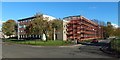
Overburn Avenue and Park Crescent
Image is on the right; that picture shows it before this work took place. Comparison of the present picture with Image, taken shortly after the completion of the work, shows that the buildings on Overburn Avenue were also included in the work.
Image: © Lairich Rig
Taken: 14 Oct 2018
0.11 miles
7
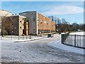
Park Crescent
Park Crescent is shown here from the point where it leaves Overburn Avenue, part of which is visible in the foreground; compare the later Image, a wider view.
The red sandstone building visible through the trees at the end of the road is Braehead Primary School.
Work took place on the buildings of Park Crescent in 2018. It is shown during that work in Image, and shortly after its completion in Image
Image: © Lairich Rig
Taken: 8 Jan 2010
0.11 miles
8

Brock Bowling Club
When this picture was taken, the new club house and green shown here appeared to be almost complete (construction began in the latter half of 2011), but the club had not yet relocated from its previous site (Image, beside Dumbarton Academy on Image).
Image: © Lairich Rig
Taken: 1 Jan 2012
0.11 miles
9
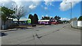
Poplar Road, Dumbarton
The view is from the junction with Overburn Avenue, and it provides context for pictures of murals that can be seen across the road: Image / Image
Image: © Lairich Rig
Taken: 13 May 2018
0.11 miles
10

Tullochan building detail
The building is beside Image See Image for the mural on the side. The artwork on this building and on an adjacent one (Image) is new.
Image: © Lairich Rig
Taken: 21 Apr 2018
0.12 miles