IMAGES TAKEN NEAR TO
Glen Orchy Crescent, DUMBARTON, G82 2BX
Introduction
This page details the photographs taken nearby to Glen Orchy Crescent, G82 2BX by members of the Geograph project.
The Geograph project started in 2005 with the aim of publishing, organising and preserving representative images for every square kilometre of Great Britain, Ireland and the Isle of Man.

There are currently over 7.5m images from over14,400 individuals and you can help contribute to the project by visiting https://www.geograph.org.uk
Image Map
Images are licensed for reuse under creativecommons.org/licenses/by-sa/2.0
Notes
- Clicking on the map will re-center to the selected point.
- The higher the marker number, the further away the image location is from the centre of the postcode.
Image Listing (115 Images Found)
Images are licensed for reuse under creativecommons.org/licenses/by-sa/2.0
Image
Details
Distance
1
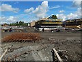
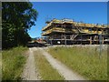
Construction at Lomondgate
Housing developments first occupied the cleared area shown in Image, and then advanced to the west, as shown here.
Image: © Lairich Rig
Taken: 13 May 2018
0.01 miles
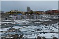
2
Cleared area at Lomondgate
The houses in the middle distance were still under construction, as part of the Lomondgate development. The line of sight between the photographer's position and those houses would, until recently, have been blocked by trees.
The picture was taken from a walkway, though it is partly obscured by mud in this view.
Compare the following "before" and "after" views: Image, taken at a time when the trees were still present, with Image, which shows the same area from the same place, but which was taken after the trees were cleared.
Image: © Lairich Rig
Taken: 5 Apr 2015
0.01 miles
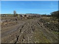
3
Construction at Lomondgate
The built-up area is extending westwards.
Image: © Lairich Rig
Taken: 18 Mar 2018
0.02 miles
4
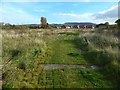
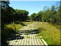
Path from SUDS pond to Lomondgate housing
The path leads from a Image, and it consists of permeable paving.
There used to be trees on both sides of this path: Image They were cleared, and the path made very muddy, when the houses visible ahead were being built: Image The present picture shows the area beginning to recover.
The path leads into the housing at Lomondgate: Image
Image: © Lairich Rig
Taken: 28 Oct 2016
0.03 miles
5
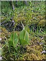
Common Twayblade
(Neottia ovata; formerly Listera ovata)
These plants were at the edge of the woods just to the north of the path that is shown in Image; that is, the woods that are to the left of the path in that picture.
Sadly, as a later picture taken from the same place reveals, those woods are gone, and hence so are the Twayblades that grew there: Image
Image: © Lairich Rig
Taken: 19 Jun 2009
0.03 miles
6
Walkway leading to SUDS pond
The walkway leads from the site of the Lomondgate development towards a Image and the River Leven. See Image for a view in the opposite direction.
Compare Image, corresponding to the present view, but taken shortly after the trees beside the walkway had been cleared away.
Image: © Lairich Rig
Taken: 17 Jun 2010
0.03 miles
7
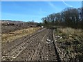
Cleared area at Lomondgate
An earlier view very closely corresponds this one, except that trees were still present to the left of the walkway: Image They were cleared shortly before the present picture was taken, as described at Image The associated flora lost with the trees included Image
The area eventually looked a little better after construction of the houses visible ahead had finished: Image
Image: © Lairich Rig
Taken: 5 Apr 2015
0.04 miles
8
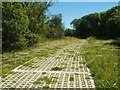
Walkway leading from SUDS pond
The walkway leads from a Image, and is made of the same material as Image It leads towards the site of the Lomondgate development.
Compare Image
A later picture corresponds almost exactly with the present view, except that the trees to the left have been cleared, greatly altering the appearance of the area: Image
Image: © Lairich Rig
Taken: 17 Jun 2010
0.04 miles
9
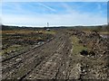
Cleared area at Lomondgate
Compare the present picture, taken shortly after trees were cleared from the side of the walkway, with a corresponding earlier picture that was taken when the trees were still present: Image
In the background of the present picture is a soil drilling rig on its support vehicle (see Image).
Image: © Lairich Rig
Taken: 5 Apr 2015
0.04 miles
10
Construction at Lomondgate
The view is from about the same place as Image, but is in the opposite direction. As noted there, the area of housing is being extended to the west.
Image: © Lairich Rig
Taken: 24 Jun 2018
0.05 miles