IMAGES TAKEN NEAR TO
Castlegreen Street, DUMBARTON, G82 1JD
Introduction
This page details the photographs taken nearby to Castlegreen Street, G82 1JD by members of the Geograph project.
The Geograph project started in 2005 with the aim of publishing, organising and preserving representative images for every square kilometre of Great Britain, Ireland and the Isle of Man.

There are currently over 7.5m images from over14,400 individuals and you can help contribute to the project by visiting https://www.geograph.org.uk
Image Map
Images are licensed for reuse under creativecommons.org/licenses/by-sa/2.0
Notes
- Clicking on the map will re-center to the selected point.
- The higher the marker number, the further away the image location is from the centre of the postcode.
Image Listing (145 Images Found)
Images are licensed for reuse under creativecommons.org/licenses/by-sa/2.0
Image
Details
Distance
1
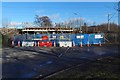
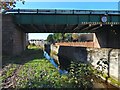
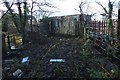
Road closed under a railway bridge
The bridge carries the railway line over Castlegreen Street; the nearest station is Dumbarton East.
The road heading off to the right leads to a sewage works: Image Those carrying out the work on the bridge were based nearby, beside the Image
Image: © Lairich Rig
Taken: 9 Feb 2018
0.06 miles
2
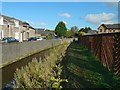
Gruggies Burn at Buchanan Street
The burn here runs parallel to Buchanan Street, which is on the left, behind the wall. It is probably safe to assume(*) that the street was named after Dr Buchanan (d.1871; see Image), who lived in nearby Knoxland House (now gone; see Image).
(*) In this connection, I consulted the cuttings in Dumbarton Library: they do not give the reason for the name Buchanan Street, but they do mention that it was known as Boundary Street until at least 1901.
Image: © Lairich Rig
Taken: 16 Oct 2015
0.09 miles
3
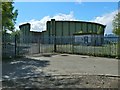
Disused gasometer, Castlegreen, Dumbarton
There are barriers over the huge gash in the side. For a nearer view, through the fence, see Image At the time of writing, the gasometer is shown on the 1:25000 map.
Image: © Lairich Rig
Taken: 14 May 2017
0.09 miles
4
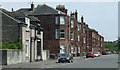
Castlegreen Street
Looking east near the junction with Bruce Street.
Image: © Thomas Nugent
Taken: 12 Jul 2013
0.10 miles
5
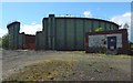
Disused gasometer, Castlegreen, Dumbarton
At the time of writing, the gasometer is marked on the 1:25000 map. For its statistics, see https://canmore.org.uk/site/43392/dumbarton-gasworks (at Canmore); as noted there, it went into operation in 1953.
For a view from further back, see Image; the present view is through the fence, not from inside it.
Image: © Lairich Rig
Taken: 14 May 2017
0.10 miles
6
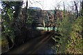
Gruggies Burn flowing under railway bridge
The burn is alongside and flowing parallel to Buchanan Street (see Image). The railway bridge is only about 100 metres SSE of the platform of Dumbarton East station.
Image: © Lairich Rig
Taken: 16 Oct 2015
0.11 miles
7
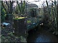
Disused railway bridge over Gruggies Burn
Dumbarton Rock can be seen indistinctly in the background. Click on the first end-note title for other views of the bridge.
The point where the track crossed Castle Road is shown in Image and Image With redevelopment of both sides of that road for housing, the rails shown there have been removed.
The sewage works whose northern entrance is at the point where the old track left the main railway line is Image: Image
Image: © Lairich Rig
Taken: 19 Jan 2018
0.11 miles
8
Disused railway bridge over Gruggies Burn
Image: © Lairich Rig
Taken: 19 Jan 2018
0.11 miles
9
Disused railway bridge over Gruggies Burn
The 1:25000 map shows this bridge, which crosses the burn obliquely. See Image for more information, and that picture and Image for side-on views.
Image: © Lairich Rig
Taken: 19 Jan 2018
0.11 miles
10
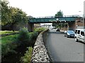
Railway bridge
The Gruggie Burn runs beside Buchanan Street before both pass under the railway line just south of Dumbarton East Station.
Image: © Richard Sutcliffe
Taken: 1 Sep 2023
0.12 miles