IMAGES TAKEN NEAR TO
Almora Drive, DUMBARTON, G82 1AE
Introduction
This page details the photographs taken nearby to Almora Drive, G82 1AE by members of the Geograph project.
The Geograph project started in 2005 with the aim of publishing, organising and preserving representative images for every square kilometre of Great Britain, Ireland and the Isle of Man.

There are currently over 7.5m images from over14,400 individuals and you can help contribute to the project by visiting https://www.geograph.org.uk
Image Map
Images are licensed for reuse under creativecommons.org/licenses/by-sa/2.0
Notes
- Clicking on the map will re-center to the selected point.
- The higher the marker number, the further away the image location is from the centre of the postcode.
Image Listing (35 Images Found)
Images are licensed for reuse under creativecommons.org/licenses/by-sa/2.0
Image
Details
Distance
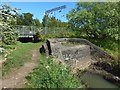
1
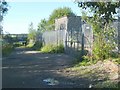
End of footpath to shore
See Image
The building on the right is Dogs Loan pumping station. Ahead, on the left, is a railway underpass (shown from the other side here: Image); on its far side is the beach.
Image: © Lairich Rig
Taken: 22 Aug 2008
0.10 miles
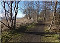
2
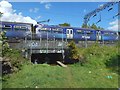
Railway underpass
The cramped tunnel is shown from another angle in Image For more context, see Image The underpass is shown from the other side in Image
Image: © Lairich Rig
Taken: 14 May 2017
0.10 miles
3
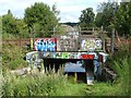
Railway underpass
The same underpass is shown from the other side here: Image For a view from another angle, see Image; for more context, see Image
Hunter's Burn (see Image) flows through the centre of the underpass; pedestrians who are prepared to stoop over can also get through by using the ledges on either side of the burn.
Image: © Lairich Rig
Taken: 22 Aug 2008
0.10 miles
4
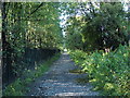
Footpath to shore
See Image
The path is perhaps called Dog's Loan; Dog's Loan Pumping Station is at its southern end.
Hunter's Burn rises at a well which is located at the south-western side of the base of Dumbowie Hill (Image); although diverted beneath nearby areas of housing, the burn reappears above ground near this point, and follows the side of this footpath; at the end of the path, the burn flows underneath a railway underpass (Image) before emerging onto the beach (Image).
The OS Object Name Book (1890s), giving authority for the name's appearance on the map, describes the burn as "a small stream on the High Mains of Dumbuck. The name is not generally known, but the proprietor wishes it to be adopted. The name has its origins not from a person's name but [from] the sportsmen or Hunters". On High Mains of Dumbuck, see Image and Image
Image: © Lairich Rig
Taken: 22 Aug 2008
0.11 miles
5
Outflow of Hunter's Burn
The burn flows through the centre of the Image (Image) in the background, and then emerges from the concrete structure in the foreground, to flow into the Clyde: Image
Image: © Lairich Rig
Taken: 14 May 2017
0.11 miles
6
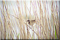
Reed Warbler (Acrocephalus scirpaceus) At Dumbuck
This singing male was present at the RSPB reserve on the Inner Clyde between 2 June and 4 July 2005. This is an improvised digiscoped image using an Opticron Imagic 80/45 telescope and 34xW HR eyepiece in conjunction with the camera.
Image: © James T M Towill
Taken: 6 Jun 2005
0.12 miles
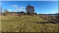
7
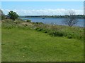
Dumbarton Foreshore Walk
At the end of the nineteenth century, the area from here to about 200 metres ahead was part of a rifle range; see Image The distance just given is approximate; the 1896 map does not specify the boundaries or the extent of the rifle range.
Image: © Lairich Rig
Taken: 9 Feb 2018
0.12 miles
8
Dumbarton Foreshore: former rifle range
This part of the foreshore is labelled "Rifle Range" on the second-edition OS map (1896); that includes not just the clear lane that is presently a path, but also the overgrown area just to the left of it.
See also Image, a view back from near the eastern end of the former rifle range. As far as I know, there are no visible remains.
Image: © Lairich Rig
Taken: 9 Feb 2018
0.12 miles
9
Dumbarton foreshore
The view is from a Image The vessel in the distance is the Clyde Puffer VIC 32; I obtained some close-up photographs of it as it passed. Here is where it was four days earlier: Image
Image: © Lairich Rig
Taken: 14 May 2017
0.13 miles
10

Dumbarton and Ben Lomond
The 3195ft (974m) high mountain dominates the backdrop in this telephoto view from Old Greenock Road to the west of Bishopton.
Image: © Thomas Nugent
Taken: 5 Apr 2015
0.13 miles