IMAGES TAKEN NEAR TO
Russell Road, CLYDEBANK, G81 6JP
Introduction
This page details the photographs taken nearby to Russell Road, G81 6JP by members of the Geograph project.
The Geograph project started in 2005 with the aim of publishing, organising and preserving representative images for every square kilometre of Great Britain, Ireland and the Isle of Man.

There are currently over 7.5m images from over14,400 individuals and you can help contribute to the project by visiting https://www.geograph.org.uk
Image Map
Images are licensed for reuse under creativecommons.org/licenses/by-sa/2.0
Notes
- Clicking on the map will re-center to the selected point.
- The higher the marker number, the further away the image location is from the centre of the postcode.
Image Listing (39 Images Found)
Images are licensed for reuse under creativecommons.org/licenses/by-sa/2.0
Image
Details
Distance
1
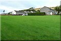
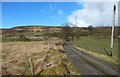
Houses on the outskirts of Duntocher
The houses on the left are on Fynloch Place. The ones on the right face Russell Road. Seen from beside the Thomas Wood Path.
Image: © Richard Sutcliffe
Taken: 1 Oct 2021
0.07 miles
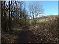
2
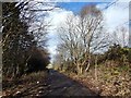
The Thomas Wood Path
This is a view from about halfway along the path, looking east, towards the point where it meets the western end of Beeches Road in Duntocher.
Image: © Lairich Rig
Taken: 10 Mar 2014
0.08 miles
3
The Thomas Wood Path
This is the western end of the path; here, it branches off from the Image
The houses are on Fynloch Place, just off Russell Road. As is clearer at larger image sizes, the object in the sky above those houses is not a bird, but a metallic silver-blue dolphin balloon which happened to drift by, originating not far to the south-west (see the map).
Image: © Lairich Rig
Taken: 10 Mar 2014
0.10 miles
4

The Thomas Wood Path
This is a view west, towards the Image end of the path.
Image: © Lairich Rig
Taken: 10 Mar 2014
0.10 miles
5
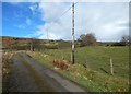
Carleith farm track
As shown on the map, the line of the Antonine Wall crosses the track here; throughout much of this area, its course is barely evident, if it all, from the ground. A nearby path was originally going to be named after the Antonine Wall, whose course it closely follows, but it was renamed to commemorate a local man: http://www.geograph.org.uk/snippet/10824
There is a mound to the right (east) of the track, as the picture shows (the view direction was chosen to highlight it); however, published reports do not identify that mound as a remnant of the Wall, and its presence here therefore seems to be coincidental.
Although there are no real surface traces of it here, the course of the Wall and of its ditch in this area have been determined by means of excavation. See https://canmore.org.uk/site/43261/antonine-wall-old-kilpatrick-mount-pleasant-duntocher at Canmore for details, not just for this point, but for nearby sections of the Wall.
See Image for a view from further along the same track.
Image: © Lairich Rig
Taken: 11 Mar 2014
0.11 miles
6
Carleith farm track
The view is as in Image, but from a point further along the track. On the left are a fenced enclosure and, further away, two masts; the enclosure and the masts are depicted on the 1:25000 map.
Image: © Lairich Rig
Taken: 11 Mar 2014
0.11 miles
7
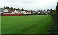
Outskirts of Duntocher
Some of the houses at the western end of Duntocher. Seen from beside the Thomas Wood Path.
Image: © Richard Sutcliffe
Taken: 1 Oct 2021
0.11 miles
8
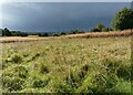
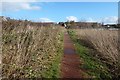
Long grass
Seen from beside the Thomas Wood Path on an afternoon of sunshine and showers. It's hard to believe that the busy A82 dual carriageway is just over 100m away.
Image: © Richard Sutcliffe
Taken: 1 Oct 2021
0.12 miles
9
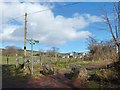
Path from Mountblow Road
See Image for a view in the opposite direction from the other end of the path. About 90 metres ahead, this path, heading north, crosses the Thomas Wood Path; there is a signpost at the junction.
Image: © Lairich Rig
Taken: 10 Mar 2014
0.12 miles
10
Start of path to Old Kilpatrick
The picture was taken from the starting point, which is shown in Image The Thomas Wood Path heads east from there, while the path to Old Kilpatrick, as shown in the present picture, heads west from the same point.
Along much of this first part of the route there is a hedge to the left (south) of the path; that hedge marks the boundary of Image (compare that picture). The hedge to the right (north) separates the path from a field.
Image: © Lairich Rig
Taken: 11 Mar 2014
0.12 miles