IMAGES TAKEN NEAR TO
Cochno Road, CLYDEBANK, G81 5QR
Introduction
This page details the photographs taken nearby to Cochno Road, G81 5QR by members of the Geograph project.
The Geograph project started in 2005 with the aim of publishing, organising and preserving representative images for every square kilometre of Great Britain, Ireland and the Isle of Man.

There are currently over 7.5m images from over14,400 individuals and you can help contribute to the project by visiting https://www.geograph.org.uk
Image Map
Images are licensed for reuse under creativecommons.org/licenses/by-sa/2.0
Notes
- Clicking on the map will re-center to the selected point.
- The higher the marker number, the further away the image location is from the centre of the postcode.
Image Listing (52 Images Found)
Images are licensed for reuse under creativecommons.org/licenses/by-sa/2.0
Image
Details
Distance
1
Rock face near Whitehill
The rock exposure, shown in the opposite direction in Image, is marked on large-scale mapping.
For the nature of the formation (most probably Douglas Muir Quartz-Conglomerate overlying volcaniclastic sediment), see Image
Image: © Lairich Rig
Taken: 15 Jul 2015
0.04 miles
2
Rock face near Whitehill
The view is from a Image, and the power lines, shown on the map, provide confirmation of the view direction.
In the woods to the north-west of the path are similar rock exposures, and remains of quarry pits: Image / Image / Image
Image: © Lairich Rig
Taken: 15 Jul 2015
0.05 miles
3
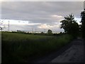
View back to Glasgow
From Cochno Road.
Image: © Stephen Sweeney
Taken: 20 Jun 2008
0.06 miles
4
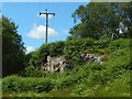
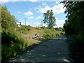
Path meeting Cochno Road
The view is from further along a path that is shown in Image
The upper signs point out that Faifley is 200 yards back along this path, and that Craigton is 2 miles ahead.
The lower signs, which bear the logo of Rotary International, point out that the same paths are part of a route called the Clyde Coastal Path. That route leads up to the road (as shown here), continues to the right (east) for about 60 metres along the road (as shown in Image), and then heads north-west from the other side of the road.
This part of Cochno Road coincides with the boundary between the council areas of West Dunbartonshire (which is on this side of the road) and East Dunbartonshire.
The Clyde Coastal Path (CCP) itself runs from Ayrshire to the West Highland Way near Milngavie. However, the shorter sections of the CPP from Faifley to Cochno Road, and from Cochno Road to Craigton, are core paths of their respective council areas.
Image: © Lairich Rig
Taken: 15 Jul 2015
0.06 miles
5
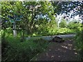
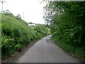
Cochno Road
The Clyde Coastal Path heads towards Cochno Road from the south, as shown in Image, follows the road itself for about 60 metres, as shown in the present picture, then heads away from the other side of the road, by means of a path whose beginning can be seen beside the signs; see Image for a view along that path.
It is in crossing this road that the Faifley to Craigton path leaves West Dunbartonshire and enters East Dunbartonshire.
Image: © Lairich Rig
Taken: 15 Jul 2015
0.06 miles
6
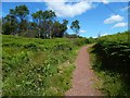
Path to Craigton
Compare Image, where this path is shown heading away from the road. The present picture was taken from near the beginning of the path, which, at this point, has left the council area of West Dunbartonshire and has entered East Dunbartonshire (see the end-note).
From here to about a kilometre along the path, there are groups of cup-marked stones nearby, some of which are marked on the OS map.
See also Image, a view to the west from roughly this point on the path, with links to views of geological features nearby.
For a view from further along the path, see Image
Image: © Lairich Rig
Taken: 15 Jul 2015
0.06 miles
7
Cochno Road
Looking towards Whitehill Farm.
Image: © Stephen Sweeney
Taken: 7 Jun 2009
0.07 miles
8
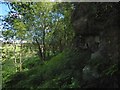
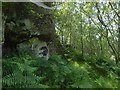
Rock face near Whitehill
The formation is at Image, and is shown from the other side in Image
It is rather shaded in the present view, but for a closer and better look, and for the probable nature of the formation, see Image
As explained there, I take the upper part, a conglomerate with well-rounded quartz pebbles, to be Douglas Muir Quartz-Conglomerate, and the lower parts may be the Kirkwood Formation (volcaniclastic sediments).
At the top of the exposure is an antiquity, though not one that is marked on the map: Image It is fortunate that it was not quarried away; there is an Image just a few metres away from it, near the top of the exposure.
Image: © Lairich Rig
Taken: 15 Jul 2015
0.07 miles
9
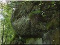
Rock face detail
This is a closer view of the feature shown in Image and, from the other side, in Image; the line of the rock exposure is marked on large-scale mapping.
The pebbles that can be seen here are mostly quartz, rounded by water, and this upper part of the exposure is probably an example of the Douglas Muir Quartz-Conglomerate (DMQ), whose type locality is nearby Douglas Muir Quarry (not far to the north-east, at Image – see the map). DMQ is a member of the Lawmuir Formation.
DMQ is said to rest apparently unconformably on volcaniclastic sediments of the Kirkwood Formation (KRW); geological maps show that formation in this area, and it most probably makes up the lower parts of this rock exposure.
Image: © Lairich Rig
Taken: 15 Jul 2015
0.07 miles
10
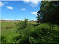
The edge of the woods
The woods, shown on large-scale mapping, lie between a field and a Image
Just within the border of the woods, and near the point from which the present picture was taken, are some rock exposures, which are also marked on large-scale mapping: Image / Image
Image: © Lairich Rig
Taken: 15 Jul 2015
0.07 miles