IMAGES TAKEN NEAR TO
Alnwick Drive, GLASGOW, G68 0GR
Introduction
This page details the photographs taken nearby to Alnwick Drive, G68 0GR by members of the Geograph project.
The Geograph project started in 2005 with the aim of publishing, organising and preserving representative images for every square kilometre of Great Britain, Ireland and the Isle of Man.

There are currently over 7.5m images from over14,400 individuals and you can help contribute to the project by visiting https://www.geograph.org.uk
Image Map
Images are licensed for reuse under creativecommons.org/licenses/by-sa/2.0
Notes
- Clicking on the map will re-center to the selected point.
- The higher the marker number, the further away the image location is from the centre of the postcode.
Image Listing (8 Images Found)
Images are licensed for reuse under creativecommons.org/licenses/by-sa/2.0
Image
Details
Distance
1
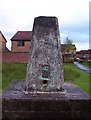
Carrickstone Trig
Situated just a few steps away from the Carrick Stone in this high spot of Cumbernauld.
Image: © Robert Murray
Taken: 9 Jun 2007
0.21 miles
2
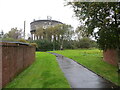
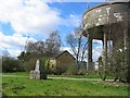
Pathway and Water Tower at Carrickstone
Looking northward. Carrickstone Triangulation Pillar can also be seen.
Image: © Peter Wood
Taken: 3 Oct 2020
0.21 miles
3
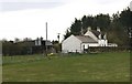
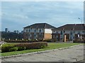
North Muirhead Farm
One of Cumbernauld's original farms.
Many were demolished and built over as the new town
developed but this one has survived.
Image: © Texas Radio and The Big Beat
Taken: 22 Apr 2010
0.21 miles
4
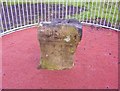
The Carrick Stone
Allegedly a Roman altar. It certainly looks as if it could have been part of a bigger object. The long since demolished Carrickstone farm and the present surrounding suburb is named after the stone.
Image: © Robert Murray
Taken: 9 Jun 2007
0.21 miles
5
Carrickstone water tower
Until recently Carrickstone was a hilltop farm, the trigpoint in a hedge at the side of a lane. Now it has been swallowed up by new housing in Cumbernauld. The water tower is a hilltop landmark.
Image: © Richard Webb
Taken: 7 Apr 2005
0.21 miles
6
Auld cley road
This is a modern path which follows an old parish/Roman road, leading towards Cumbernauld community park, further along this road, the original track is more evident. It is recorded as Roman and Drovers...via Flavii. On this road is the Carrickstone which is said to be the meeting place of Robert the Bruce. A good view of the surrounding valleys is evident further on.
Image: © carrickstone emily
Taken: 6 Jan 2012
0.22 miles
7
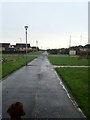
Portland Road, Carrickstone
And a distant view across Cumbernauld.
Image: © Stephen Sweeney
Taken: 16 Apr 2014
0.23 miles
8
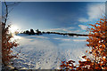
Dullatur Golf Course
Dullatur Golf Course, November 27 2010
Image: © Simon Walsh
Taken: 26 Nov 2010
0.23 miles