IMAGES TAKEN NEAR TO
Banton, Kilsyth, GLASGOW, G65 0QX
Introduction
This page details the photographs taken nearby to G65 0QX by members of the Geograph project.
The Geograph project started in 2005 with the aim of publishing, organising and preserving representative images for every square kilometre of Great Britain, Ireland and the Isle of Man.

There are currently over 7.5m images from over14,400 individuals and you can help contribute to the project by visiting https://www.geograph.org.uk
Image Map
Images are licensed for reuse under creativecommons.org/licenses/by-sa/2.0
Notes
- Clicking on the map will re-center to the selected point.
- The higher the marker number, the further away the image location is from the centre of the postcode.
Image Listing (28 Images Found)
Images are licensed for reuse under creativecommons.org/licenses/by-sa/2.0
Image
Details
Distance
2
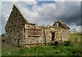
Boon the Mire Farmhouse (ruin)
Image: © Texas Radio and The Big Beat
Taken: 19 Aug 2010
0.04 miles
3
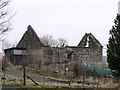
Old Binniemyre farmhouse
Or 'Boon the Mire' as it was so named on the First Ed. O.S. Stirling Sht. XXIX.2. surveyed in 1859. www.nls.uk/maps/os/25inch/view/?sid=74983761
Image: © Robert Murray
Taken: 18 Feb 2010
0.05 miles
4
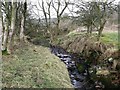
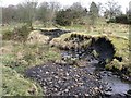
Craigdouffie Burn (W)
This burn rises in the high braes south-east of the Tak-ma-doon road and flows down through the 'Boiling Glen' to the west of Binniemyre where it joins the eastern tributary south-west of the farm. There the naming confusion begins as the O.S. name both streams 'Craigdoufie Burn' in different maps.
Image: © Robert Murray
Taken: 18 Feb 2010
0.07 miles
5
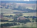
Bingland
Although only one and part of another is visible in this photograph there are seven almost equally sized small bings (think olympic rings with two extra above the five) in this field N.E. of Binniemyre. All featured on the First Ed. O.S. of 1859 Stirling Sht. XXIX.2. www.nls.uk/maps/os/25inch/view/?sid=74983761 and are typical of small scale early 19th. century mining on the braes of the Kilsyth Hills.
Image: © Robert Murray
Taken: 18 Feb 2010
0.08 miles
6
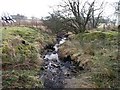
Craigdouffie Burn (W)
A view of the stretch near Binniemyre.
Image: © Robert Murray
Taken: 18 Feb 2010
0.08 miles
7
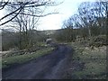
The Slipe road
To and from High Banton via Mailings and Binniemyre. Don't go with your wedding shoes on.
Image: © Robert Murray
Taken: 13 Mar 2010
0.08 miles
8
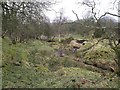
Craigdouffie Burn (W) outcrop revealed
Both coal and ironstone outcrop in this area and here it can be seen in the banks of the nameless burn just west of Binniemyre. It is also interesting to note the destruction caused to the banks by this wee burn when it is in spate.
Image: © Robert Murray
Taken: 18 Feb 2010
0.10 miles
9
Craigdouffie Burn (W)
Flowing towards its confluence with the eastern tributary.
Image: © Robert Murray
Taken: 18 Feb 2010
0.10 miles
10
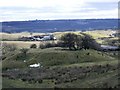
One of the Seven Sisters
One bing chosen at random to illustrate an image that is typical of the other six. Meadowside Farm down the hill.
Image: © Robert Murray
Taken: 13 Mar 2010
0.13 miles