IMAGES TAKEN NEAR TO
Dullatur Road, GLASGOW, G65 0DN
Introduction
This page details the photographs taken nearby to Dullatur Road, G65 0DN by members of the Geograph project.
The Geograph project started in 2005 with the aim of publishing, organising and preserving representative images for every square kilometre of Great Britain, Ireland and the Isle of Man.

There are currently over 7.5m images from over14,400 individuals and you can help contribute to the project by visiting https://www.geograph.org.uk
Image Map
Images are licensed for reuse under creativecommons.org/licenses/by-sa/2.0
Notes
- Clicking on the map will re-center to the selected point.
- The higher the marker number, the further away the image location is from the centre of the postcode.
Image Listing (36 Images Found)
Images are licensed for reuse under creativecommons.org/licenses/by-sa/2.0
Image
Details
Distance
1
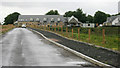
New houses
Still under construction.
Image: © Richard Sutcliffe
Taken: 18 Jun 2018
0.00 miles
3
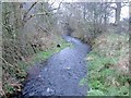
Levee on the Shawend Burn
There must be a flooding risk on the haugh from this burn - which becomes a fully fledged river in times of heavy spate.
Image: © Robert Murray
Taken: 21 Jan 2010
0.16 miles
4
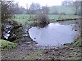
Weir on the Shawend Burn
Before the weir was built in order to divert water to the canal feeder [just off to right of photo] and thence the Forth & Clyde Canal this burn flowed unimpeded round this meander and onward to meet Kelvin Water. On the upper reaches of this burn the O.S. have seen fit to name it the Banton Burn. See also http://www.geograph.org.uk/photo/1623000
Image: © Robert Murray
Taken: 17 Dec 2009
0.17 miles
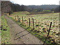
5
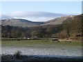
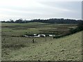
Horses grazing on the floodplain
The flood plain of the Kelvin at the narrow gap between Barwood and Dullatur. The road from Kilsyth town and Dullatur twists across the middle of the photo. The unseen canal feeder runs along the contour at the treeline on the right.
Image: © Robert Murray
Taken: 30 Jan 2010
0.17 miles
6
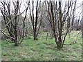
Woodland, Woodend
Scrubby woodland between the new A803 alignment and the older road to the south.
Image: © Richard Webb
Taken: 30 Sep 2011
0.17 miles
7
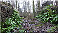
Natural fernery
Ferns adorning some old buildings
Image: © Angela Jones
Taken: 15 Jan 2017
0.18 miles
8
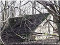
Old air shaft, Currymire
This curious looking building covers encloses what was sunk as a winding shaft for a 2km long haulage road which was driven from the Haugh pit at Kilsyth in 1923 to exploit a 1.25m thick seam of coal. However mining lasted only 12 years due to geological faults (Whin dykes) hemming in the seam on one side and flood water from the abandoned Riskend workings which finished extraction from this valuable seam.
Image: © Robert Murray
Taken: 10 Feb 2010
0.18 miles
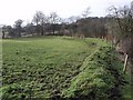
9
Grazing Land
East of Kilsyth, the A803, Kilsyth - Banknock road is at the treeline.
Image: © Robert Murray
Taken: 21 Jan 2010
0.19 miles
10
Canal feeder to Forth & Clyde Canal
After being siphoned off from the Shawend burn.
Image: © Robert Murray
Taken: 17 Dec 2009
0.19 miles