IMAGES TAKEN NEAR TO
Westbourne Crescent, GLASGOW, G61 4HE
Introduction
This page details the photographs taken nearby to Westbourne Crescent, G61 4HE by members of the Geograph project.
The Geograph project started in 2005 with the aim of publishing, organising and preserving representative images for every square kilometre of Great Britain, Ireland and the Isle of Man.

There are currently over 7.5m images from over14,400 individuals and you can help contribute to the project by visiting https://www.geograph.org.uk
Image Map
Images are licensed for reuse under creativecommons.org/licenses/by-sa/2.0
Notes
- Clicking on the map will re-center to the selected point.
- The higher the marker number, the further away the image location is from the centre of the postcode.
Image Listing (35 Images Found)
Images are licensed for reuse under creativecommons.org/licenses/by-sa/2.0
Image
Details
Distance
1
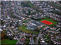
Castlehill Primary School from the air
The shiny new sports pitch is probably visible from the moon! Here is a http://www.castlehill.e-dunbarton.sch.uk/ to the school's web site.
Image: © Thomas Nugent
Taken: 3 Nov 2017
0.03 miles
2
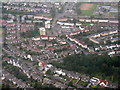
Roman Park and houses at Bearsden
The main road across the top of the picture is Duntocher Road [A810]. The course of the Antonine Wall runs through Roman Park, the strip of woodland at lower right.
Image: © M J Richardson
Taken: 3 Oct 2015
0.04 miles
3
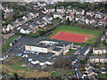
Castlehill Primary School from the air
Like other schools in the area, very prominent from the air due to its red sports pitch.
Image: © Thomas Nugent
Taken: 24 Jan 2020
0.05 miles
4
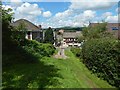
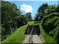
Steps leading down to Iain Road
These steps lead out of the western end of Roman Park, and down to Iain Road, part of which is visible ahead.
Close to the point from which this picture was taken, the line of the Antonine Wall changes direction, as the map shows. The Wall heads west towards this point (compare Image), but then turns to head north-west for a distance of about 250 metres before resuming a more westerly course.
This flight of steps is on the line of the Wall, and is on the same SE-NW alignment, so, as well as being a view down the steps, this picture is a view along the line of this part (built over with housing) of the Antonine Wall.
For a view back up the steps, see Image
Image: © Lairich Rig
Taken: 3 Jul 2015
0.06 miles
5
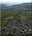
Bearsden from the air
Looking along the course of the Antonine Wall to Castle Hill, the Widening River Clyde and Dumbarton Rock can be seen in the distance, beyond the Erskine Bridge.
Image: © Thomas Nugent
Taken: 7 Apr 2016
0.07 miles
6
Steps leading up to Roman Park
The steps lead up from Iain Road (compare Image, a view back down them).
The line of the steps (heading south-east as they ascend) is on top of, and parallel to, the course of the Antonine Wall. Not far beyond the top of the flight of steps, the Wall makes an abrupt change in direction, to head east, as is shown on the map, and in a view from further ahead: Image
Image: © Lairich Rig
Taken: 3 Jul 2015
0.08 miles
8

Roman Park
The area shown here is near the western entrance of the park. The ground slopes down here from the rampart to the ditch of the Antonine Wall. The line of the rampart is among the trees at the top of the slope, while the line of the ditch is among the trees on the left.
Further to the east, there is a clear view along the line of the rampart (Image), and a preserved section of its stone base is displayed there (Image).
Image: © Lairich Rig
Taken: 3 Jul 2015
0.11 miles
9

Path through Roman Park
The ditch of the Antonine Wall is nearby; it forms a slight hollow beside the path, but it is greatly overgrown at this time of year.
Image: © Lairich Rig
Taken: 3 Jul 2015
0.12 miles
10
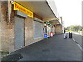
Shops, Kenilworth Crescent
The Bearsden Fryer (Traditional Fish and Chips) and Kenilworth Food Store (Day Today Express).
Image: © Richard Sutcliffe
Taken: 29 Sep 2017
0.12 miles