IMAGES TAKEN NEAR TO
Antonine Road, GLASGOW, G61 4DS
Introduction
This page details the photographs taken nearby to Antonine Road, G61 4DS by members of the Geograph project.
The Geograph project started in 2005 with the aim of publishing, organising and preserving representative images for every square kilometre of Great Britain, Ireland and the Isle of Man.

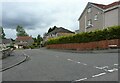
There are currently over 7.5m images from over14,400 individuals and you can help contribute to the project by visiting https://www.geograph.org.uk
Image Map
Images are licensed for reuse under creativecommons.org/licenses/by-sa/2.0
Notes
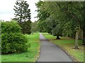
- Clicking on the map will re-center to the selected point.
- The higher the marker number, the further away the image location is from the centre of the postcode.
Image Listing (45 Images Found)
Images are licensed for reuse under creativecommons.org/licenses/by-sa/2.0
Image
Details
Distance
1
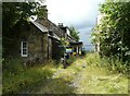
Castlehill Farm
Empty farmhouse and associated buildings, fenced off with 'Danger - Keep Out' signs.
Image: © Richard Sutcliffe
Taken: 8 Aug 2021
0.03 miles
2
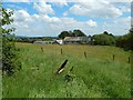
Castlehill Farm
The view is from the summit of Image
Image: © Lairich Rig
Taken: 3 Jul 2015
0.04 miles
3
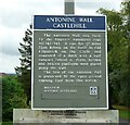
Sign: Antonine Wall Castlehill
The Antonine Wall was built
by the Emperor Antonius Pius
AD 142-143. It ran for 37 miles
from Bo’ness on the Forth to Old
Kilpatrick on the Clyde and
consisted of a ditch with a turf
rampart behind it. Forts, fortlets
and beacon platforms were placed
along the wall.
The line of the Antonine Wall
is preserved by the open ground
running East from this notice.
Cared for by
Historic Scotland
Image
Image: © Richard Sutcliffe
Taken: 8 Aug 2021
0.05 miles
4
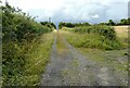
Track to Castlehill
The track leads from the A810, Duntocher Road to Castlehill Farm.
Image: © Richard Sutcliffe
Taken: 8 Aug 2021
0.06 miles
5
Eagle Crescent
At the junction with Antonine Road.
Image: © Richard Sutcliffe
Taken: 8 Aug 2021
0.06 miles
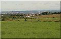
6
Houses, Bearsden
Seen from the top of Castle Hill.
Image: © Richard Sutcliffe
Taken: 8 Aug 2021
0.06 miles
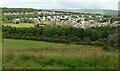
7
Western end of Bearsden
The houses on Antonine Road are on the very edge of Bearsden, looking onto farmland.
The line of the Antonine Wall follows the hedge line just to the right of the houses up to Castle Hill.
Image: © Richard Sutcliffe
Taken: 14 Jul 2016
0.06 miles
8
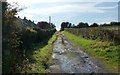
Track to Castle Hill
The picture was taken from near the point where this track begins at Duntocher Road. For the hill itself, see Image; it is the site of a Roman fort on the Antonine Wall. The houses on the left are on Antonine Road.
Image: © Lairich Rig
Taken: 5 Oct 2007
0.08 miles
9
Line of the Antonine Wall
The line of the Antonine Wall is preserved by the open ground running between Antonine Road and Rosslyn Road. It is a Scheduled Monument http://portal.historicenvironment.scot/designation/SM6898.
Image: © Richard Sutcliffe
Taken: 8 Aug 2021
0.08 miles
10
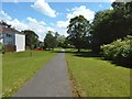
The course of the Antonine Wall
The path and the open space beside it preserve the line of the Antonine Wall. The picture was taken from a point 200m further along the path shown in Image, but the view is in the opposite direction.
Image: © Lairich Rig
Taken: 3 Jul 2015
0.08 miles