IMAGES TAKEN NEAR TO
Barlia Drive, GLASGOW, G45 0AX
Introduction
This page details the photographs taken nearby to Barlia Drive, G45 0AX by members of the Geograph project.
The Geograph project started in 2005 with the aim of publishing, organising and preserving representative images for every square kilometre of Great Britain, Ireland and the Isle of Man.

There are currently over 7.5m images from over14,400 individuals and you can help contribute to the project by visiting https://www.geograph.org.uk
Image Map
Images are licensed for reuse under creativecommons.org/licenses/by-sa/2.0
Notes
- Clicking on the map will re-center to the selected point.
- The higher the marker number, the further away the image location is from the centre of the postcode.
Image Listing (37 Images Found)
Images are licensed for reuse under creativecommons.org/licenses/by-sa/2.0
Image
Details
Distance
1
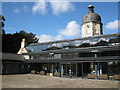
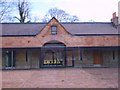
Castlemilk Stables
Stables block for the now demolished Castlemilk House. Recently restored by Elder and Cannon for the Glasgow Building Preservation Trust.
Image: © Graeme Yuill
Taken: 18 Sep 2010
0.08 miles
2
Castlemilk Stables
Built as the stables block for the now demolished Castlemilk House. The building has been recently restored by Elder and Cannon for Glasgow Building Preservation Trust.
Image: © Graeme Yuill
Taken: 18 Sep 2010
0.08 miles
3
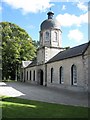
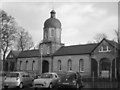
Castlemilk East Parish Church
Former Parish of the Rev. John Miller, he retired in 2007 after serving his parish for over 30 years.
Image: © Lynn M Reid
Taken: 7 Mar 2008
0.09 miles
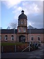
4
Castlemilk House Stables
Seen from the south. This Category B listed building [http://portal.historicenvironment.scot/designation/LB33720] dating from the 1790s is now a centre for the local community, restored and run by the Cassiltoun Trust [http://www.cassiltountrust.org.uk/index.html]. It contains the local Housing Association offices, training suites, childcare facilities and space for community events.
Image: © Richard Sutcliffe
Taken: 30 Jun 2018
0.09 miles
5
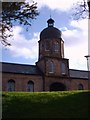
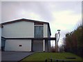
Clock Tower
Dome was added as part of the restoration.
Image: © Lynn M Reid
Taken: 7 Mar 2008
0.09 miles
6
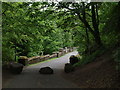
Path onto Castlemilk Bridge
Beside Castlemilk Stables this road heads down among trees to Castlemilk Bridge (Image).
Image: © Alec MacKinnon
Taken: 20 May 2018
0.10 miles
7
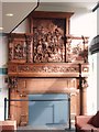
The Castlemilk Fireplace.
This fireplace was created in 1794. It depicts the Battle Of Orleans- 1429, where two Stuart brothers perished. It stands 15ft high and was rescued during the demolition of Castlemilk House in 1969. It was returned to Castlemilk in the early 2000's were it was housed in the CEDA building. It now has pride of place in the recently refurbished Castlemilk Stables.
Image: © Lynn M Reid
Taken: 7 Mar 2008
0.10 miles
9
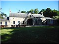
Courtyard of Castlemilk Stables
This building is now home to the local Housing Association.
Image: © Lynn M Reid
Taken: 7 Mar 2008
0.10 miles
10
Castlemilk Stables
Recently refurbished after many years of neglect. Originally built in 1794, prior to restoration only the surrounding walls survived.
Image: © Lynn M Reid
Taken: 7 Mar 2008
0.10 miles