IMAGES TAKEN NEAR TO
Huntershill Court, GLASGOW, G21 3AD
Introduction
This page details the photographs taken nearby to Huntershill Court, G21 3AD by members of the Geograph project.
The Geograph project started in 2005 with the aim of publishing, organising and preserving representative images for every square kilometre of Great Britain, Ireland and the Isle of Man.

There are currently over 7.5m images from over14,400 individuals and you can help contribute to the project by visiting https://www.geograph.org.uk
Image Map
Images are licensed for reuse under creativecommons.org/licenses/by-sa/2.0
Notes
- Clicking on the map will re-center to the selected point.
- The higher the marker number, the further away the image location is from the centre of the postcode.
Image Listing (35 Images Found)
Images are licensed for reuse under creativecommons.org/licenses/by-sa/2.0
Image
Details
Distance
1
Balgrayhill Road
The photograph was taken from the junction with Belmont Road.
The large building on the right was formerly the Marie Curie Hospice (Glasgow). At the time that this picture was taken, the hospice had been relocated to a new building, a little over 300 metres to the north-east, within the grounds of Image
Image: © Lairich Rig
Taken: 11 Oct 2010
0.02 miles
2
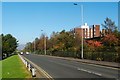
Balgrayhill Road
At Belmont Road, which leads to Stobhill Hospital. Ben Lomond is visible in the distance, above the towerblocks.
Image: © Thomas Nugent
Taken: 1 Dec 2012
0.09 miles
3
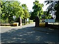
Entrance to Springburn Park
Off Belmont Road.
Image: © Richard Sutcliffe
Taken: 6 Jun 2023
0.10 miles
4
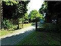
Entrance to Mosesfield Memorial Garden
A peaceful area of contemplation within Springburn Park, with informal memorials to lost loved ones.
Image: © Richard Sutcliffe
Taken: 6 Jun 2023
0.10 miles
5
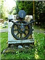
Memorial to Hyde Park Works
A memorial (presumably) to the North British Railway Company's Hyde Park Works in Springburn. It comprises a wheel on a section of rail; a leaf spring; and brake; with a buffer above. It is located within Mosesfield Memorial Garden, but there does not appear to be any information about it.
Image: © Richard Sutcliffe
Taken: 6 Jun 2023
0.11 miles
6

Viewpoint Road
The photograph was taken from Image
In the distance, near the left-hand edge of the picture, is the tower of the Image
Also visible in the background, in the right-hand side of the photograph, is the lava plateau of the Kilpatrick Hills, extending from the Slacks (Image), which can be seen near the centre of the photo, as far as to the foot of the Campsie Hills (where the very distinctive horn of Dumgoyne (Image), visible above the rightmost house, is located).
Out of shot, 50 metres to the south-west of the photographer's position, was one of the high flats of Viewpoint Place (Image); these stand in the highest part of Glasgow, and their upper floors must command a spectacular view.
Image: © Lairich Rig
Taken: 11 Oct 2010
0.11 miles
7
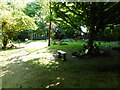
Mosesfield Memorial Garden
A peaceful area of contemplation within Springburn Park, with informal memorials to lost loved ones.
Image: © Richard Sutcliffe
Taken: 6 Jun 2023
0.12 miles
8
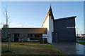
Skye House
Part of the Stobhill Hospital campus.
Image: © Thomas Nugent
Taken: 1 Dec 2012
0.12 miles
9

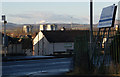
Farmfoods
Frozen food store just off Springburn Road.
Image: © Stephen Sweeney
Taken: 27 May 2009
0.13 miles
10
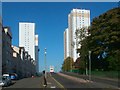
Balgrayhill flats
The tower blocks were completed in 1967. The two on the left are in Viewpoint Place, while the two on the right are on Balgrayhill Road.
See Image for a view from a different angle.
Image: © Lairich Rig
Taken: 11 Oct 2010
0.15 miles