Viewpoint Road
Introduction
The photograph on this page of Viewpoint Road by Lairich Rig as part of the Geograph project.
The Geograph project started in 2005 with the aim of publishing, organising and preserving representative images for every square kilometre of Great Britain, Ireland and the Isle of Man.

There are currently over 7.5m images from over 14,400 individuals and you can help contribute to the project by visiting https://www.geograph.org.uk
Viewpoint Road
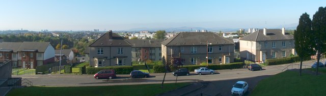
Image: © Lairich Rig Taken: 11 Oct 2010
The photograph was taken from Image In the distance, near the left-hand edge of the picture, is the tower of the Image Also visible in the background, in the right-hand side of the photograph, is the lava plateau of the Kilpatrick Hills, extending from the Slacks (Image), which can be seen near the centre of the photo, as far as to the foot of the Campsie Hills (where the very distinctive horn of Dumgoyne (Image), visible above the rightmost house, is located). Out of shot, 50 metres to the south-west of the photographer's position, was one of the high flats of Viewpoint Place (Image); these stand in the highest part of Glasgow, and their upper floors must command a spectacular view.
Images are licensed for reuse under creativecommons.org/licenses/by-sa/2.0
Image Location
Latitude
55.891916
Longitude
-4.230307