IMAGES TAKEN NEAR TO
Peters Marland, TORRINGTON, EX38 8QU
Introduction
This page details the photographs taken nearby to EX38 8QU by members of the Geograph project.
The Geograph project started in 2005 with the aim of publishing, organising and preserving representative images for every square kilometre of Great Britain, Ireland and the Isle of Man.

There are currently over 7.5m images from over14,400 individuals and you can help contribute to the project by visiting https://www.geograph.org.uk
Image Map
Images are licensed for reuse under creativecommons.org/licenses/by-sa/2.0
Notes
- Clicking on the map will re-center to the selected point.
- The higher the marker number, the further away the image location is from the centre of the postcode.
Image Listing (10 Images Found)
Images are licensed for reuse under creativecommons.org/licenses/by-sa/2.0
Image
Details
Distance
2
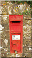
Postbox, Peters Marland
Victorian postbox number EX38 53 is on the wall of the churchyard, as seen in Image
Image: © Derek Harper
Taken: 21 Jun 2019
0.04 miles
3
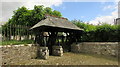
Lych gate, Peters Marland
"Likely to be 1868 - the date the church was rebuilt ... The lych gate consists of 3 posts on stone plinths supporting the roof with diagonal struts intersected by curved braces" https://historicengland.org.uk/listing/the-list/list-entry/1162219 . The walls and railings are also described in the listing.
Image: © Derek Harper
Taken: 21 Jun 2019
0.04 miles
4

Peters Marland
The village street curves past a cottage and numerous trees.
Image: © Derek Harper
Taken: 21 Jun 2019
0.05 miles
5
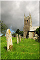
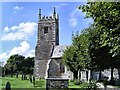
Church of St Peter, Peters Marland
From the lych gate. "Some C15 fabric survives in tower but mainly rebuilt in 1868" https://historicengland.org.uk/listing/the-list/list-entry/1309763 .
Image: © Derek Harper
Taken: 21 Jun 2019
0.05 miles
6
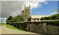
Church of St Peter, Peters Marland
This view of the listed church (see also Image]) also looks up the lane towards Berry Cross. The wall on the right is also part of the listing for the lych gate https://historicengland.org.uk/listing/the-list/list-entry/1162219 with "chamfered coping stones".
Image: © Derek Harper
Taken: 21 Jun 2019
0.05 miles
7
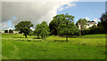
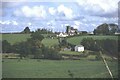
Near Peters Marland
A broader view from where Image was taken, with some of the farm buildings at Combe on the left, and Rose Cottage on the right. The River Mere runs through the meadow towards the right of the camera;
Image: © Derek Harper
Taken: 21 Jun 2019
0.12 miles
8
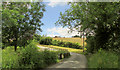
Lane to Peters Marland
Looking right from where Image] was taken, with the lane from Wollaton curving left as it crosses the River Mere.
Image: © Derek Harper
Taken: 21 Jun 2019
0.14 miles
9
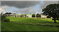
Combe, Peters Marland
The farm is west of the village, and seen here from the lane from Wollaton as the sun returns after a brief shower.
Image: © Derek Harper
Taken: 21 Jun 2019
0.20 miles