IMAGES TAKEN NEAR TO
Old Rydon Lane, EXETER, EX2 7JW
Introduction
This page details the photographs taken nearby to Old Rydon Lane, EX2 7JW by members of the Geograph project.
The Geograph project started in 2005 with the aim of publishing, organising and preserving representative images for every square kilometre of Great Britain, Ireland and the Isle of Man.

There are currently over 7.5m images from over14,400 individuals and you can help contribute to the project by visiting https://www.geograph.org.uk
Image Map
Images are licensed for reuse under creativecommons.org/licenses/by-sa/2.0
Notes
- Clicking on the map will re-center to the selected point.
- The higher the marker number, the further away the image location is from the centre of the postcode.
Image Listing (70 Images Found)
Images are licensed for reuse under creativecommons.org/licenses/by-sa/2.0
Image
Details
Distance
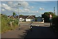
1
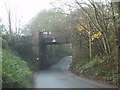
Railway bridge over Old Rydon Lane
Image: © Sarah Charlesworth
Taken: 9 Dec 2009
0.08 miles
2
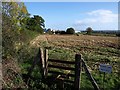
Field near Sandy Park Farm
The situation described in Image A stile lies on either side of the Avocet railway line beside Old Rydon Close, but there's no right of way continuing across this field towards the farm and the new Exeter Chiefs Stadium beyond, shown in Image
Image: © Derek Harper
Taken: 4 Nov 2009
0.09 miles
3
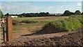
Field near Sandy Park
A field to the west of Image], with housieng on Old Rydon lan on the left, and Old Rydon Close to the right. I'm afraid I can't work out what the purple flowers are.
Image: © Derek Harper
Taken: 3 Jun 2017
0.09 miles
4
Track to the M5
The (private) field access track then runs alongside the motorway, finally bending away from it to reach a field next to the railway line. Across the motorway is the Clyst Works of PGL Training, accessed from Clyst Road beyond. The large road sign on the M5 (you can see the reverse of it) will be concerned with the impending Junction 30. On the horizon is Topsham Water Tower Image
Image: © Derek Harper
Taken: 3 Jun 2017
0.10 miles
5
House, Sandy Park
Sandy Park Lodge seen from the access road, shown in Image], to the Exeter Chiefs' stadium and Sandy Park Farm. The road it meets is Old Rydon Lane. Signs indicate foot and cycle routes to Newcourt station (right) and Clyst St Mary.
Image: © Derek Harper
Taken: 3 Jun 2017
0.10 miles
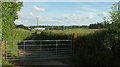
6
Where does this go?
A gate off old Rydon Lane. Complete with all the appropriate warning signs relating to trains. Doesn't appear to go anywhere.
Image: © Anthony Vosper
Taken: 13 Nov 2013
0.10 miles
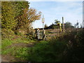
7

Old Rydon Close
The red notice forbids vehicular traffic beyond this point, but it's a useful link for pedestrians and cyclists through to Russell Way and the Grange development at the former Digby hospital. On the right is a stile, always tempting to the rambler, which leads straight across the adjacent railway track. It's only when you've crossed it that you find it doesn't lead to anything publicly accessible.
Image: © Derek Harper
Taken: 4 Nov 2009
0.10 miles
8
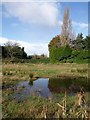
Vacant land, Old Rydon Close
A vacant plot, partly flooded, by Old Rydon Lane. Sites like this must help provide varied habitats for wildlife, although it seems inevitable that it will be built on at some stage.
Image: © Derek Harper
Taken: 4 Nov 2009
0.11 miles
9

Exeter : Courtyard by Marriott
A hotel near Sandy Park.
Image: © Lewis Clarke
Taken: 7 Mar 2022
0.11 miles
10
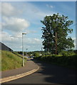
Road at Sandy Park
Providing access to the Exeter Chiefs' stadium and to Sandy Park Farm. Bee orchids flourish on the bank on the left.
Image: © Derek Harper
Taken: 3 Jun 2017
0.11 miles