IMAGES TAKEN NEAR TO
Hobbacott Lane, BUDE, EX23 0ES
Introduction
This page details the photographs taken nearby to Hobbacott Lane, EX23 0ES by members of the Geograph project.
The Geograph project started in 2005 with the aim of publishing, organising and preserving representative images for every square kilometre of Great Britain, Ireland and the Isle of Man.

There are currently over 7.5m images from over14,400 individuals and you can help contribute to the project by visiting https://www.geograph.org.uk
Image Map
Images are licensed for reuse under creativecommons.org/licenses/by-sa/2.0
Notes
- Clicking on the map will re-center to the selected point.
- The higher the marker number, the further away the image location is from the centre of the postcode.
Image Listing (17 Images Found)
Images are licensed for reuse under creativecommons.org/licenses/by-sa/2.0
Image
Details
Distance
1
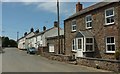
Houses in Marhamchurch
On Hobbacott Lane at the east end of the village.
Image: © Derek Harper
Taken: 31 May 2016
0.15 miles
2
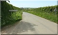
Approaching Marhamchurch
Down Hobbacott Lane past the village name sign, with the tower of St Marwenna's church visible.
Image: © Derek Harper
Taken: 31 May 2016
0.15 miles
3

Houses in Marhamchurch
The principal route through the villages makes a double bend past these houses.
Image: © Derek Harper
Taken: 31 May 2016
0.17 miles
4

Seat on Hobbacott Lane
Image] from the other direction, I'm becoming slightly obsessive about recording these, having often trudged so many miles without seeing one. Here, of course, I'm ashamed to admit I have a car to climb into a few metres down the road. Further down it is Marhamchurch - see Image
Image: © Derek Harper
Taken: 31 May 2016
0.21 miles
5

Seat on Hobbacott Lane
With the crossroads ahead from which Image was taken.
Image: © Derek Harper
Taken: 31 May 2016
0.21 miles
6

Stone walls and stone facing, Marhamchurch
Image: © David Smith
Taken: 14 Apr 2016
0.22 miles
7
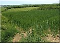
Crop east of Marhamchurch
Looking to the left from the same gate as Image, towards the head of the valley of a tributary of the Neet or Strat.
Image: © Derek Harper
Taken: 31 May 2016
0.23 miles
8
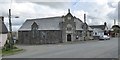
The "Bray", the village's Church of England Institute
Image: © David Smith
Taken: 14 Apr 2016
0.23 miles
9
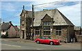
Church of England Institute, Marhamchurch
Also shown in Image Described at https://www.historicengland.org.uk/listing/the-list/list-entry/1141805 as "Arts and Crafts, free Tudor style", the building, with its "grand 2-storey gabled corner porch", is listed. The thatched cottage on the left is also listed https://www.historicengland.org.uk/listing/the-list/list-entry/1278402 .
Image: © Derek Harper
Taken: 31 May 2016
0.24 miles
10
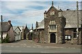
Top of Pinch Hill, Marhamchurch
On the right is Image] https://www.historicengland.org.uk/listing/the-list/list-entry/1141805 , on the left Rosamund Cottage https://www.historicengland.org.uk/listing/the-list/list-entry/1278402 , and down the hill is the Methodist Church Image, with its hall on this side.
Image: © Derek Harper
Taken: 31 May 2016
0.24 miles