IMAGES TAKEN NEAR TO
Furley, AXMINSTER, EX13 7TT
Introduction
This page details the photographs taken nearby to EX13 7TT by members of the Geograph project.
The Geograph project started in 2005 with the aim of publishing, organising and preserving representative images for every square kilometre of Great Britain, Ireland and the Isle of Man.

There are currently over 7.5m images from over14,400 individuals and you can help contribute to the project by visiting https://www.geograph.org.uk
Image Map
Images are licensed for reuse under creativecommons.org/licenses/by-sa/2.0
Notes
- Clicking on the map will re-center to the selected point.
- The higher the marker number, the further away the image location is from the centre of the postcode.
Image Listing (16 Images Found)
Images are licensed for reuse under creativecommons.org/licenses/by-sa/2.0
Image
Details
Distance
1
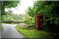
Hook Cross Furley
This is the view from the small lane with the old red telephone box that runs up into Furley Village from Thorn Lane.
Image: © Nigel Mykura
Taken: 7 Aug 2015
0.05 miles
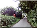
3
Membury: telephone box at Furley
By Hook Cross, looking north east
Image: © Martin Bodman
Taken: 2 Dec 2006
0.06 miles
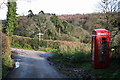
5
Membury: Goodlands, Furley
Thatch and hedge near Hook Cross, looking east-south-east. In the valley of a Yarty tributary
Image: © Martin Bodman
Taken: 2 Dec 2006
0.07 miles
6

Furley
View down Long Orchard which at one time ran down to the large house of Rokehay Farm (spelt Roakhay on old maps) but now terminates at several more recent properties.
Image: © Nigel Mykura
Taken: 7 Aug 2015
0.08 miles
7

Cattle near Furley
From close to the spot where Image was taken.
Image: © Derek Harper
Taken: 16 May 2013
0.09 miles
8
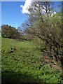
Valley near Furley
Looking up the valley that Image looks down, with trees hiding the stream on the right. This is the foot of the field occupied by cattle in Image
Image: © Derek Harper
Taken: 16 May 2013
0.12 miles

10

Track near Furley
With the wooded valley shown in Image on the left. The (private) track leads to Rokehay Farm. Bluebells adorn the bank on the right.
Image: © Derek Harper
Taken: 16 May 2013
0.15 miles