IMAGES TAKEN NEAR TO
Chardstock, AXMINSTER, EX13 7DB
Introduction
This page details the photographs taken nearby to EX13 7DB by members of the Geograph project.
The Geograph project started in 2005 with the aim of publishing, organising and preserving representative images for every square kilometre of Great Britain, Ireland and the Isle of Man.

There are currently over 7.5m images from over14,400 individuals and you can help contribute to the project by visiting https://www.geograph.org.uk
Image Map
Images are licensed for reuse under creativecommons.org/licenses/by-sa/2.0
Notes
- Clicking on the map will re-center to the selected point.
- The higher the marker number, the further away the image location is from the centre of the postcode.
Image Listing (8 Images Found)
Images are licensed for reuse under creativecommons.org/licenses/by-sa/2.0
Image
Details
Distance
2
Road between Holy City and Chardstock
Looking in the direction of Holy City
Image: © Peter Holmes
Taken: 20 Nov 2009
0.16 miles
3
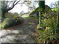
Track to Ransomes Farm
Public Bridleway continues on to Brinscombe Cottage and Challenger Farm.
Image: © Peter Holmes
Taken: 20 Nov 2009
0.19 miles
4
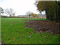
Field near Cuckold's Pit
The view on the right side of the lane shown in Image On the right is a small unnamed wood. On the far side of the field is the road between Holy City and Chardstock. Beyond is the Kit valley.
Image: © Derek Harper
Taken: 16 May 2013
0.20 miles
5

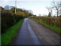
Lane to Holy City
Over 500 metres further north along the lane from Image, but a similar scene, with the hillside still on the left. Above the field is the track to Ransomes Farm.
Image: © Derek Harper
Taken: 16 May 2013
0.20 miles
7
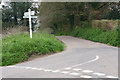
Chardstock: Holy City Cross
Looking south-south-west
Image: © Martin Bodman
Taken: 30 Apr 2006
0.24 miles
8

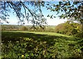
Trees along former field boundary near Cuckold's Pit
These are at the northern end of the elongated field shown in Image], seen from the same lane. At the rear, a track descends to Claysteps.
Image: © Derek Harper
Taken: 16 May 2013
0.25 miles