IMAGES TAKEN NEAR TO
Wagtail Walk, AXMINSTER, EX13 5GX
Introduction
This page details the photographs taken nearby to Wagtail Walk, EX13 5GX by members of the Geograph project.
The Geograph project started in 2005 with the aim of publishing, organising and preserving representative images for every square kilometre of Great Britain, Ireland and the Isle of Man.

There are currently over 7.5m images from over14,400 individuals and you can help contribute to the project by visiting https://www.geograph.org.uk
Image Map
Images are licensed for reuse under creativecommons.org/licenses/by-sa/2.0
Notes
- Clicking on the map will re-center to the selected point.
- The higher the marker number, the further away the image location is from the centre of the postcode.
Image Listing (9 Images Found)
Images are licensed for reuse under creativecommons.org/licenses/by-sa/2.0
Image
Details
Distance
2

Axminster : Housing Development
A housing development in Axminster.
Image: © Lewis Clarke
Taken: 9 Jul 2016
0.07 miles
3
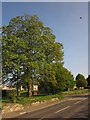
Trees by the Chard Road
The A358 passes First Avenue on the left, heading into Axminster.
Image: © Derek Harper
Taken: 25 May 2013
0.10 miles
4
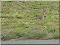
Axminster: bunny on the verge
This rabbit was spotted on the verge of the A358 on the northern outskirts of Axminster.
Image: © Chris Downer
Taken: 27 Sep 2008
0.13 miles
5

Second Avenue, Axminster
A road of modern housing turns off the A358 Chard Road north of the town.
Image: © Derek Harper
Taken: 25 May 2013
0.16 miles
6
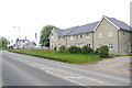
New Houses on the Fosse Way
Nothing to show that these new houses on the main road out of Axminster to the north, the A358 to Chard are standing on what was once a roman road.
Image: © Nigel Mykura
Taken: 23 May 2015
0.16 miles
7
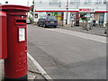
Axminster: Millwey Rise Post Office and postbox № EX13 124
Millwey Rise Post Office was not originally one of the 2,500 selected for closure during 2008. But, after the reprieve of a few Devon offices initially threatened, this one was substituted. It will close some time in the autumn but to mitigate the effects of the closure, some form of replacement or 'outreach' service is being considered, such as a visiting mobile office.
Attached to the left of the postbox, partially visible, is a drop box (see below).
Image: © Chris Downer
Taken: 27 Sep 2008
0.18 miles
8
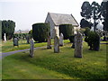
Axminster cemetery
This cemetery is about half a mile from the ancient churchyard of Axminster which closed in 1855.
Image: © Peter Holmes
Taken: 18 Mar 2009
0.18 miles
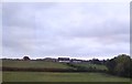
9
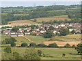
Industrial estate and new housing
Seen across the Axe Valley is new expansion out of Axminster along the Chard Road which here follows the Fosse Way
Image: © William Bartlett
Taken: 27 Aug 2006
0.19 miles