IMAGES TAKEN NEAR TO
Beavor Lane, AXMINSTER, EX13 5EQ
Introduction
This page details the photographs taken nearby to Beavor Lane, EX13 5EQ by members of the Geograph project.
The Geograph project started in 2005 with the aim of publishing, organising and preserving representative images for every square kilometre of Great Britain, Ireland and the Isle of Man.

There are currently over 7.5m images from over14,400 individuals and you can help contribute to the project by visiting https://www.geograph.org.uk
Image Map
Images are licensed for reuse under creativecommons.org/licenses/by-sa/2.0
Notes
- Clicking on the map will re-center to the selected point.
- The higher the marker number, the further away the image location is from the centre of the postcode.
Image Listing (24 Images Found)
Images are licensed for reuse under creativecommons.org/licenses/by-sa/2.0
Image
Details
Distance
1
Orange Way in Devon and Torbay (502)
The horror continues - see
Image
Image: © Shazz
Taken: 18 Apr 2012
0.05 miles
2

Orange Way in Devon and Torbay (501)
This was a nasty shock. I was expecting a pleasant footpath and discovered a building site.
Image: © Shazz
Taken: 18 Apr 2012
0.08 miles
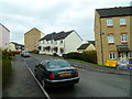
3
Millbrook Meadows
A new housing development seen across the A358; the junction can be seen in Image The road you can see here is Cherry Tree Road.
Image: © Derek Harper
Taken: 25 May 2013
0.08 miles
4

Public footpath to Sector Park
Once an open field now fenced footpath with site for new houses.
Image: © Peter Holmes
Taken: 18 Mar 2009
0.09 miles
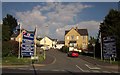
6

A358 approaching Millbrook Cross
The Chard Road dropping down past cottages and the turning into a close of new houses at Millbrook Meadows (see Image), to the junction at a bridge over the Mill Brook. Over to the right on this side of the brook is farmland.
Image: © Derek Harper
Taken: 25 May 2013
0.11 miles
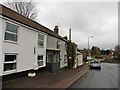
7

A358 at Millbrook Cross
Millbrook Cross is just to the right. On the right, the Chard Road is climbing the hill seen from the other direction in Image On the left is pasture sloping down to the Mill Brook.
Image: © Derek Harper
Taken: 25 May 2013
0.11 miles

9
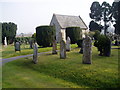
Axminster cemetery
This cemetery is about half a mile from the ancient churchyard of Axminster which closed in 1855.
Image: © Peter Holmes
Taken: 18 Mar 2009
0.11 miles
10

Orange Way in Devon and Torbay (503)
This was the way to escape from the horror.
Image: © Shazz
Taken: 18 Apr 2012
0.12 miles