IMAGES TAKEN NEAR TO
Old Beer Road, SEATON, EX12 2PX
Introduction
This page details the photographs taken nearby to Old Beer Road, EX12 2PX by members of the Geograph project.
The Geograph project started in 2005 with the aim of publishing, organising and preserving representative images for every square kilometre of Great Britain, Ireland and the Isle of Man.

There are currently over 7.5m images from over14,400 individuals and you can help contribute to the project by visiting https://www.geograph.org.uk
Image Map
Images are licensed for reuse under creativecommons.org/licenses/by-sa/2.0
Notes
- Clicking on the map will re-center to the selected point.
- The higher the marker number, the further away the image location is from the centre of the postcode.
Image Listing (77 Images Found)
Images are licensed for reuse under creativecommons.org/licenses/by-sa/2.0
Image
Details
Distance
1
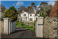
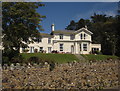
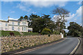
The White House
Victorian villa on Old Beer Road, marked as The Elms on the 1889 1:2,500 map, Whinhurst on the 1904 edition and White House on the 1936 and subsequent editions.
Image: © Ian Capper
Taken: 8 Feb 2020
0.02 miles
2
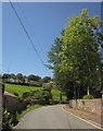
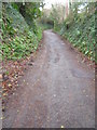
Old Beer Road
The road curving away from the junction shown in Image, and starting to climb the valley of the Beer Brook above Seaton Hole.
Image: © Derek Harper
Taken: 19 Jun 2012
0.04 miles
3
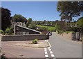
Old Beer Road at Seaton Hole
The old road passes the junction with Beer Hill, where the inland route of the South West Coast Path branches off, joining the beach route from Seaton.
Image: © Derek Harper
Taken: 19 Jun 2012
0.05 miles
4
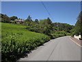
Old Beer Road
Taken from just past the derestriction sign you can just see in Image This is the valley of the Beer Brook. Pinehurst is the house on the modern B3174 which skirts the valley higher up.
Image: © Derek Harper
Taken: 19 Jun 2012
0.05 miles
5
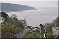
East Devon : Coastal Scenery
Looking across the coastal scenery near Seaton and Beer.
Image: © Lewis Clarke
Taken: 10 Mar 2013
0.06 miles
6
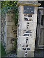
Benchmark at Lew Hollow, near Seaton
Ordnance Survey benchmark situated on gatepost to large manor house near Seaton Hole. For full description on database, see http://www.bench-marks.org.uk/bm36979.
Image: © Becky Williamson
Taken: 6 Aug 2016
0.06 miles
7
Swallowcliffe, Seaton
A residential care home overlooking the Old Beer Road, and hence the inland route of the South West Coast Path.
Image: © Derek Harper
Taken: 19 Jun 2012
0.07 miles
8
The Old Beer Road
This is the original Seaton to Beer road, before it was redirected inland.
Image: © N Chadwick
Taken: 31 Dec 2006
0.08 miles
9
Swallowcliffe
Victorian villa on Old Beer Road, marked as The Arg on the 1889 1:2,500 map and Swallowcliffe on the 1904 and subsequent editions. It is now a retirement home.
Image: © Ian Capper
Taken: 8 Feb 2020
0.08 miles
10
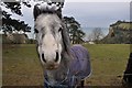
Seaton : Grassy Hillside & Horse
A horse which came to say hello to us as we walked along Beer Road.
Image: © Lewis Clarke
Taken: 10 Mar 2013
0.08 miles