IMAGES TAKEN NEAR TO
Bedford Avenue, BARNET, EN5 2EL
Introduction
This page details the photographs taken nearby to Bedford Avenue, EN5 2EL by members of the Geograph project.
The Geograph project started in 2005 with the aim of publishing, organising and preserving representative images for every square kilometre of Great Britain, Ireland and the Isle of Man.

There are currently over 7.5m images from over14,400 individuals and you can help contribute to the project by visiting https://www.geograph.org.uk
Image Map
Images are licensed for reuse under creativecommons.org/licenses/by-sa/2.0
Notes
- Clicking on the map will re-center to the selected point.
- The higher the marker number, the further away the image location is from the centre of the postcode.
Image Listing (132 Images Found)
Images are licensed for reuse under creativecommons.org/licenses/by-sa/2.0
Image
Details
Distance
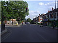
2
Meadway at the junction of Barnet Hill
Image: © David Howard
Taken: 25 Dec 2013
0.03 miles
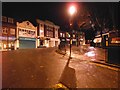
3
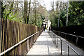
Footway to High Barnet Station
A steep footpath leading down from Barnet High Street, at the junction with Meadway, to the station entrance. Stories abound about city gents arriving at the station in an undignified manner having slid the length of the path on their bottoms in icy weather. Nowadays the pavement slabs have ridges to assist with grip.
Image: © Martin Addison
Taken: 16 Mar 2007
0.03 miles
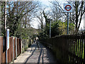
5
Barnet: Footpath to High Barnet station
High Barnet station was opened in 1872 by the Great Northern railway and until 1939 was served by steam trains, most of them to and from either Kings Cross or Broad Street, (via the Canonbury Curve). In 1939 the station closed, to reopen the following year as part of the London Underground's Northern Line, with trains to Kennington and Morden, passing under Central London via two routes - via Bank and via Charing Cross. The Northern Line remains in 2010 as the most complex of London's 'Tube' lines, and is very heavily used.
Image: © Dr Neil Clifton
Taken: 15 Apr 2010
0.04 miles
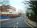
8
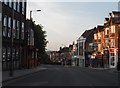
Barnet: High Street
Looking northwest from the junction with Meadway. Barnet High Street is part of the A1000.
Image: © Dr Neil Clifton
Taken: 15 Apr 2010
0.05 miles
9
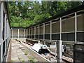
The end of the line at High Barnet tube station
This part of the station can be seen beyond the footbridge in Image
Image: © Mike Quinn
Taken: 3 Jul 2019
0.05 miles
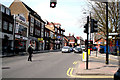
10
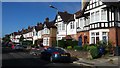
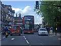
Bedford Avenue
The photograph shows the substantial terraced housing typical of this area of Barnet, north London.
Image: © Peter Mackenzie
Taken: 12 Sep 2017
0.05 miles