IMAGES TAKEN NEAR TO
Camlet Way, BARNET, EN4 0NX
Introduction
This page details the photographs taken nearby to Camlet Way, EN4 0NX by members of the Geograph project.
The Geograph project started in 2005 with the aim of publishing, organising and preserving representative images for every square kilometre of Great Britain, Ireland and the Isle of Man.

There are currently over 7.5m images from over14,400 individuals and you can help contribute to the project by visiting https://www.geograph.org.uk
Image Map
Images are licensed for reuse under creativecommons.org/licenses/by-sa/2.0
Notes
- Clicking on the map will re-center to the selected point.
- The higher the marker number, the further away the image location is from the centre of the postcode.
Image Listing (10 Images Found)
Images are licensed for reuse under creativecommons.org/licenses/by-sa/2.0
Image
Details
Distance
1
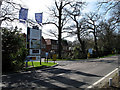
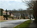
Calderwood Place
A modern gated housing development beside Camlet Way. More homes have been added as Regent Place and these are being advertised on the Hoarding.
Image: © Martin Addison
Taken: 16 Mar 2007
0.05 miles
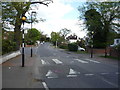
2
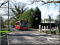
Camlet Way
DM41264 on the 399 route to Hadley Wood passes through the Monken Hadley Common gate. On the right is the entrance to Beech Hill Farm.
Image: © Martin Addison
Taken: 16 Mar 2007
0.07 miles
3
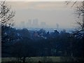
Hadley Wood with Docklands buildings in the distance
Docklands is 15 miles from here but clearly visible due to the high elevation.
Image: © Bikeboy
Taken: 13 Mar 2013
0.08 miles
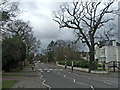
4
Camlet Way, Hadley Wood
Hadley Wood is a very exclusive area and even has its own security vans running around. This is the main road through Hadley Wood.
Image: © Marathon
Taken: 4 May 2016
0.10 miles
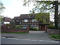
5
Broadgates Avenue
A dead end with no pedestrian way through to Monken Hadley Common.
Image: © Robin Webster
Taken: 6 Apr 2013
0.12 miles
6
Camlet Way, Hadley Wood, Hertfordshire, looking west
Looking west down Camlet Way. Camlet Corner is on the right hand side of the image.
Image: © Christine Matthews
Taken: 17 Mar 2007
0.22 miles
8
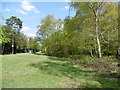
Monken Hadley Common
Monken Hadley Common is the last remaining fragment of the former Enfield Chase, which was elsewhere enclosed for agriculture in the 18th century. It was originally managed as wood pasture and a number of local people retained ancient Rights of Common, such as stock-grazing rights. Most of the Common is now woodland, although there are areas of acid grassland as here, as well as some ponds. Here Camlet Way leading to Hadley Wood is to the left of the grassland.
Image: © Marathon
Taken: 4 May 2016
0.24 miles
10
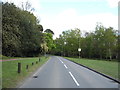
Camlet Way
Heading east, Monken Hadley Common.
Image: © JThomas
Taken: 15 Apr 2017
0.25 miles