IMAGES TAKEN NEAR TO
Brunswick Road, ENFIELD, EN3 6UL
Introduction
This page details the photographs taken nearby to Brunswick Road, EN3 6UL by members of the Geograph project.
The Geograph project started in 2005 with the aim of publishing, organising and preserving representative images for every square kilometre of Great Britain, Ireland and the Isle of Man.

There are currently over 7.5m images from over14,400 individuals and you can help contribute to the project by visiting https://www.geograph.org.uk
Image Map
Images are licensed for reuse under creativecommons.org/licenses/by-sa/2.0
Notes
- Clicking on the map will re-center to the selected point.
- The higher the marker number, the further away the image location is from the centre of the postcode.
Image Listing (76 Images Found)
Images are licensed for reuse under creativecommons.org/licenses/by-sa/2.0
Image
Details
Distance
1
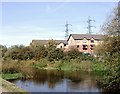
Enfield Island Village
Enfield Island Village is a housing development built between 1997-2003 and stands on the former site of the Royal Small Arms factory which closed in the 1980s. The island is bounded by various channels of the River Lea.
Image: © David Kemp
Taken: 11 Oct 2008
0.01 miles
2

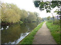
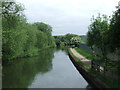
Swans on the River Lea
The original River Lea flowed 70 miles from Leagrove Marsh near Luton to the River Thames at Bow Creek. The River Lee Act of 1766 provided for the construction of 15 new cuts to straighten the course of the river by eliminating loops which made it difficult to navigate. The River Lee Navigation just west of here is one of those cuts and hence it is a navigation rather than a river.
This though is the River Lea which unlike the Lee Navigation is not accessible here. Historically the river is spelled Lea while the navigation is Lee. Just ahead on the left, part of the River Lea flows into the huge King George's Reservoir - see http://www.geograph.org.uk/photo/5357435
Image: © Marathon
Taken: 27 Sep 2017
0.05 miles
3
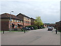
Brunswick Road, Enfield Island Village
A recent housing development on the outskirts of Greater London.
Image: © Malc McDonald
Taken: 1 Jun 2013
0.06 miles
4
The London LOOP alongside the River Lea
The original River Lea flowed 70 miles from Leagrove Marsh near Luton to the River Thames at Bow Creek. The River Lee Act of 1766 provided for the construction of 15 new cuts to straighten the course of the river by eliminating loops which made it difficult to navigate. The River Lee Navigation just west of here is one of those cuts and hence it is a navigation rather than a river. This though is the River Lea which unlike the Lee Navigation is not accessible here. Historically the river is spelled Lea while the navigation is Lee.
The London LOOP follows the River Lea here for a short distance before climbing out of the Lea Valley towards Epping Forest.
Image: © Marathon
Taken: 27 Sep 2017
0.08 miles
5
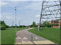
Shared path at Enfield Island Village
Signs indicate that this path is shared by pedestrians and cyclists. It forms part of National Cycle Network route 1, which stretches up the east side of Britain from Dover to the Shetland Islands.
Image: © Malc McDonald
Taken: 1 Jun 2013
0.09 miles
6
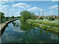
River Lee (or Lea) at Enfield Island Village
Image: © Malc McDonald
Taken: 1 Jun 2013
0.11 miles
7
Enfield Island Village
The River Lee in its artificial channel, and the modern housing of Enfield Island Village, built on the site of the Royal Small Arms factory, famous for its Lee-Enfield rifles.
Image: © Stephen Dawson
Taken: 15 May 2005
0.12 miles
8

Flood relief channel
Known variously as the Cattlegate Flood Relief Channel and the Rammey Marsh Flood Relief Channel, the main flood channel for the River Lea meets the Lea (beyond the power lines). The embankment of the King George V Reservoir is prominent.
Image: © Stephen Dawson
Taken: 15 May 2005
0.12 miles
9
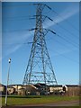
Pylon at Enfield Island Village
A pylon near the centre of Enfield Island Village - an iconic landmark for the residents.
Image: © John Leeming
Taken: 11 Jul 2007
0.12 miles
10
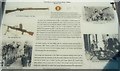
Enfield Lock Heritage Trail Board 3 of 4
Close up of this noticeboard on River Lea just south of Swan & Pike Pool car park.
Image: © Sean Davis
Taken: 21 May 2011
0.12 miles