IMAGES TAKEN NEAR TO
Waltham Gardens, ENFIELD, EN3 6PG
Introduction
This page details the photographs taken nearby to Waltham Gardens, EN3 6PG by members of the Geograph project.
The Geograph project started in 2005 with the aim of publishing, organising and preserving representative images for every square kilometre of Great Britain, Ireland and the Isle of Man.

There are currently over 7.5m images from over14,400 individuals and you can help contribute to the project by visiting https://www.geograph.org.uk
Image Map
Images are licensed for reuse under creativecommons.org/licenses/by-sa/2.0
Notes
- Clicking on the map will re-center to the selected point.
- The higher the marker number, the further away the image location is from the centre of the postcode.
Image Listing (76 Images Found)
Images are licensed for reuse under creativecommons.org/licenses/by-sa/2.0
Image
Details
Distance
1
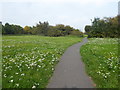
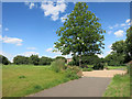
Path across Aylands Open Space
This small park is reasonably formal north of Turkey Street and the Turkey Brook but turns into the informal grassland and shrubs seen here as it approaches Aylands School.
Image: © Marathon
Taken: 27 Sep 2017
0.03 miles
2
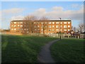
Path and flats near Enfield
A path and a low-rise block of flats in the outer suburbs of north London.
This image was taken in early February. The sun was low in the sky, shadows were long and the trees were bare for the winter season.
Image: © Malc McDonald
Taken: 1 Feb 2020
0.04 miles
3
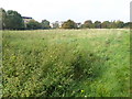
Aylands Open Space
This small park is reasonably formal north of Turkey Street and the Turkey Brook but turns into the informal grassland seen here as it comes alongside Aylands School.
Image: © Marathon
Taken: 27 Sep 2017
0.05 miles
4
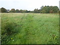
Aylands Open Space
This small park is reasonably formal north of Turkey Street and the Turkey Brook but turns into the informal grassland seen here as it comes alongside Aylands School.
Image: © Marathon
Taken: 27 Sep 2017
0.07 miles
5
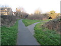
Tree and Cycleway
Part of a small park near Turkey Street station.
Image: © Des Blenkinsopp
Taken: 5 Jun 2014
0.07 miles

8
Paths near Enfield
Footpaths through a green space in north London's outer suburbs.
Image: © Malc McDonald
Taken: 1 Feb 2020
0.09 miles
9
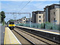
Turkey Street station
In 1890 the Great Eastern Railway opened a link known at the time as the Churchbury Loop between Bury Street Junction, Edmonton (on its line to Enfield Town) and Cheshunt (on its main line to Cambridge). One of the stations was the present Turkey Street, then known as Forty Hill. The line was not a success and the passenger service was withdrawn in 1909 in the wake of local tramway competition, although it did regain a passenger service between 1915-1919 to cater for the extra traffic generated by munitions factories in the area. However, the station was reopened to passengers as Turkey Street in 1960 as part of the electrification of the lines from Liverpool Street to Hertford, Bishop's Stortford and elsewhere.
In 2015 the lines from Liverpool Street to Enfield and elsewhere were taken over by London Overground which brought many improvements in its wake. See Image for a somewhat different view of this station.
Image: © David Kemp
Taken: 27 Sep 2008
0.09 miles
10
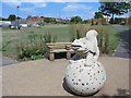
Friendly dragon
In a small park just to the east of Turkey Street station.
Image: © Mike Quinn
Taken: 30 Jul 2014
0.09 miles