IMAGES TAKEN NEAR TO
High Road, BROXBOURNE, EN10 6AE
Introduction
This page details the photographs taken nearby to High Road, EN10 6AE by members of the Geograph project.
The Geograph project started in 2005 with the aim of publishing, organising and preserving representative images for every square kilometre of Great Britain, Ireland and the Isle of Man.

There are currently over 7.5m images from over14,400 individuals and you can help contribute to the project by visiting https://www.geograph.org.uk
Image Map (Loading...)


Getting Data...Please wait
Leaflet Map data © OpenStreetMap
Images are licensed for reuse under creativecommons.org/licenses/by-sa/2.0
Notes
- Clicking on the map will re-center to the selected point.
- The higher the marker number, the further away the image location is from the centre of the postcode.
Image Listing (41 Images Found)
Images are licensed for reuse under creativecommons.org/licenses/by-sa/2.0
Image
Details
Distance
1
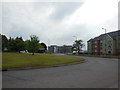
Turnford College building site
Seen here to the rear of the main building is some of the building work that is going on Hertford Regional College, Turnford.
The expansion was partly funded by selling off a lot of the grounds to build houses and flats (off to the left of the picture).
Image: © Talisman
Taken: 18 Jan 2009
0.03 miles
2
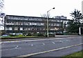
Hertford Regional College
Hertford Regional College, Turnford, Hertfordshire
Image: © Christine Matthews
Taken: 1 Jan 2006
0.03 miles
4
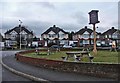
Garden of New River Arms, with pub sign and houses in High Road, Turnford, in background
Pub sign of the New River Arms, with garden, and the houses of Turnford High Road in the background
Image: © Christine Matthews
Taken: 1 Jan 2006
0.06 miles
5
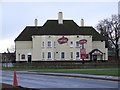
New River Arms
The New River Arms, High Road Turnford and following what was reported as a £300k refurbishment about 2 years ago is also now known as the New River Carvery.
Strangely it closed about 6 months ago.
Image: © Talisman
Taken: 18 Jan 2009
0.06 miles
7
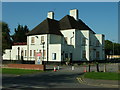
Former New River Arms, Turnford
The now closed New River Arms public house seen from The Springs. It seems likely the building will be demolished and replaced with flats.
Image: © Rob Candlish
Taken: 10 Sep 2015
0.10 miles
8
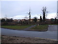
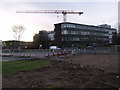
More woodland lost to housing
The picture shows the few remaining trees that are standing on what was until recently an undeveloped patch of Turnford opposite Turnford college.
One and two bedroom flats are to built on this piece of land between High Road Turnford and the Canadas development that can be seen in the background.
Supporting the current Government's policy of concreting the south east.
Image: © Talisman
Taken: 18 Jan 2009
0.11 miles
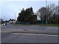
9
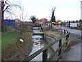
Turnford Brook and building site
In the foreground is Turnford Brook.
The building site is an area of former scrub and woodland that has been cut down to make way for one and two bedroom flats Image
Image: © Talisman
Taken: 18 Jan 2009
0.11 miles