IMAGES TAKEN NEAR TO
Mill Court, BATHGATE, EH48 4JY
Introduction
This page details the photographs taken nearby to Mill Court, EH48 4JY by members of the Geograph project.
The Geograph project started in 2005 with the aim of publishing, organising and preserving representative images for every square kilometre of Great Britain, Ireland and the Isle of Man.

There are currently over 7.5m images from over14,400 individuals and you can help contribute to the project by visiting https://www.geograph.org.uk
Image Map
Images are licensed for reuse under creativecommons.org/licenses/by-sa/2.0
Notes
- Clicking on the map will re-center to the selected point.
- The higher the marker number, the further away the image location is from the centre of the postcode.
Image Listing (11 Images Found)
Images are licensed for reuse under creativecommons.org/licenses/by-sa/2.0
Image
Details
Distance
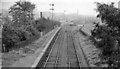
3
Bathgate Lower railway station (site)
Opened in 1856 as a branch from the Monkland Railways' line at Blackstone, this station closed to passengers as early as 1930, and closed completely in 1963.
View south east across the former level crossing, with the platforms being somewhere near the course of the minor road opposite. The main building was somewhere near where the tree in the centre of the image is. As can be seen, no trace appears to remain.
Image: © Nigel Thompson
Taken: 5 Jul 2014
0.10 miles
5
Bathgate Lower Station -- remains
View SE, towards Bathgate Upper. The station, on the branch to Bathgate Upper from Blackstone Junction on the Monklands Railway (Kirkintilloch - Causewayend), had been closed to passengers on 1/5/30, but Bathgate Lower remained open for Goods until 28/10/63 and the line was still used from Blackstone Junction until 1/5/67 and to Bathgate Upper until as late as 3/9/73. This explains the shiny rails in this picture taken in September 1962.
Image: © Ben Brooksbank
Taken: 19 Sep 1962
0.12 miles
6
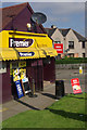
Raza Stores, Bathgate
Colourful convenience shop at the north end of Livery Street.
Image: © Stephen McKay
Taken: 7 Jun 2013
0.21 miles
7
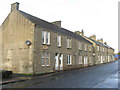
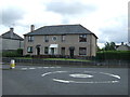
Millburn Road, Bathgate
Two short stone terraces. Each house has rounded margins to windows and doorways, just like the adjacent pair of semi-detached bungalows Image
Image: © M J Richardson
Taken: 27 Oct 2013
0.22 miles
8
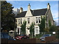
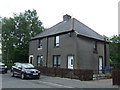
1892 house on Glasgow Road
A substantial villa on Glasgow Road in Bathgate. Details of the window and door structure are similar to those on the adjacent Millburn Road, Image Image and are presumably by the same builder/developer.
Image: © M J Richardson
Taken: 27 Oct 2013
0.23 miles
9
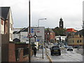
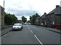
Crossroads in Bathgate
Looking east to the junction of the A89 Glasgow road with the A800 [left] to Linlithgow and Menzies Road [right] leading to the B7002 to Whitburn. The tower is the bell tower of St David's Church.
Image: © M J Richardson
Taken: 27 Oct 2013
0.24 miles
10
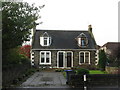
Bungalows on Millburn Road
A pair of small dwellings adjacent to a terrace of large houses, but with similar window and door features Image
Image: © M J Richardson
Taken: 27 Oct 2013
0.25 miles