IMAGES TAKEN NEAR TO
Beechgrove Road, DALKEITH, EH22 5QF
Introduction
This page details the photographs taken nearby to Beechgrove Road, EH22 5QF by members of the Geograph project.
The Geograph project started in 2005 with the aim of publishing, organising and preserving representative images for every square kilometre of Great Britain, Ireland and the Isle of Man.

There are currently over 7.5m images from over14,400 individuals and you can help contribute to the project by visiting https://www.geograph.org.uk
Image Map
Images are licensed for reuse under creativecommons.org/licenses/by-sa/2.0
Notes
- Clicking on the map will re-center to the selected point.
- The higher the marker number, the further away the image location is from the centre of the postcode.
Image Listing (14 Images Found)
Images are licensed for reuse under creativecommons.org/licenses/by-sa/2.0
Image
Details
Distance
1
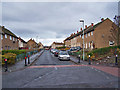
Sycamore Road, Mayfield
A traffic calmed residential street, which provides access to the nearby Mayfield Primary School.
Image: © Richard Dorrell
Taken: 13 Jan 2011
0.09 miles
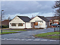
2
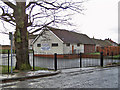
Gospel Hall, Mayfield
Located in Stone Avenue, Mayfield.
Image: © Richard Dorrell
Taken: 13 Jan 2011
0.11 miles
3
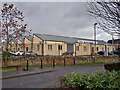
Business Park, Mayfield
Viewed from Stone Place, the business park address is Sycamore Road, Mayfield.
Image: © Richard Dorrell
Taken: 13 Jan 2011
0.14 miles
4
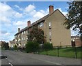
Flats in Buckie Road at Mayfield
Near Newtongrange in Midlothian.
Image: © James Denham
Taken: 2 Sep 2009
0.19 miles
5
The Huntsman public house
Located on the corner of Eskfield Road and Mayfield Place. Clearly closed, and possibly undergoing conversion into some other use.
Image: © Richard Dorrell
Taken: 13 Jan 2011
0.19 miles
6
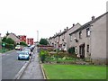
Mayfield
Part of a large 1950s housing development next to the older Newtongrange. It was built to house miners, often from closed mines elsewhere, when the local pits were developed.
Image: © Richard Webb
Taken: 11 Aug 2005
0.20 miles
7
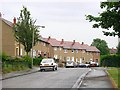
Mayfield
Houses in this large 1950's housing estate built to house miners. Now an Edinburgh dormitory. The scheme is built on a hillside and is quite high up.
Image: © Richard Webb
Taken: 11 Aug 2005
0.21 miles
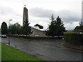
9
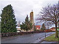
St Luke's and St Anne's Church, Mayfield
Viewed looking north along Stone Place towards Eskview Road.
Image: © Richard Dorrell
Taken: 13 Jan 2011
0.22 miles
10
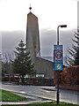
St Luke's and St Anne's Church, Mayfield
The church seen from Eskview Road.
Image: © Richard Dorrell
Taken: 13 Jan 2011
0.22 miles